
There is a point in learning to sail when the individual skills begin to come together.
You know how to steer the boat. You understand the basic points of sail. You can tack and gybe. You have learned how to read the wind, reef the sails, interpret a marine forecast, read a nautical chart, check tide tables and think about tidal currents.
Now comes a different question:
Can you use all of that information to decide whether a sailing trip makes sense?
That is passage planning.
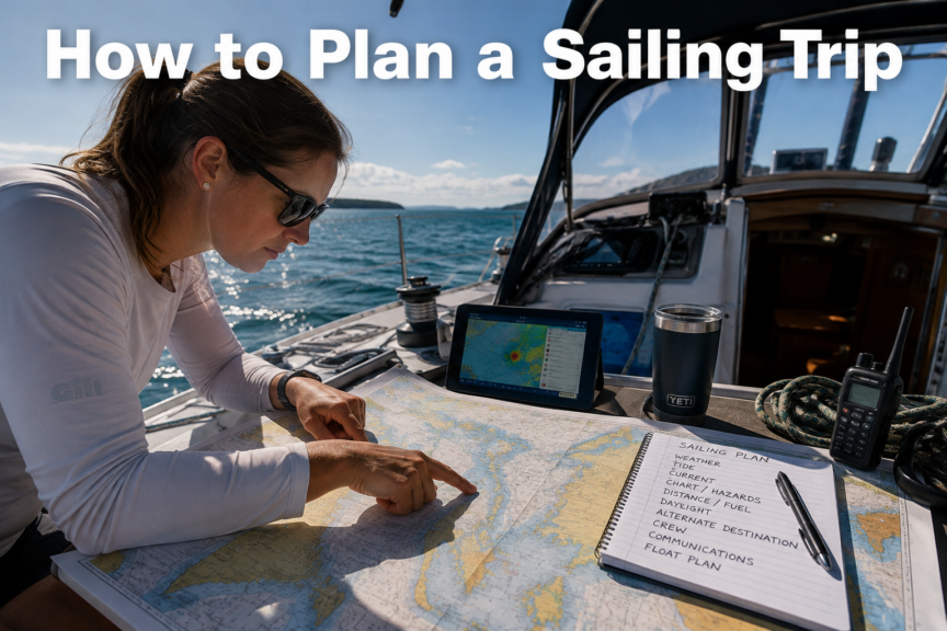
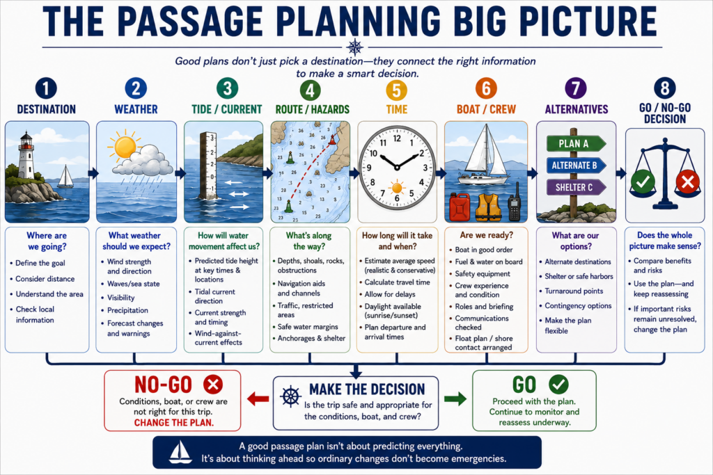
Planning a sailing trip is not simply choosing somewhere interesting on the chart and drawing a line toward it. It means considering the entire trip — weather, tides, currents, hazards, distance, daylight, fuel, crew, communications and possible alternatives — before leaving the dock.
More importantly, it means recognizing that those factors interact.
A 20-nautical-mile trip might be easy in one set of conditions and a poor decision in another.
A harbour entrance that is straightforward at high water might require much more care near low water.
A comfortable afternoon sail can become difficult if a strong opposing current delays your arrival until after sunset.
This is where sailing begins to feel less like operating a boat and more like being responsible for one.
Beginner principle: Good passage planning is not about predicting everything that will happen. It is about thinking far enough ahead that ordinary changes do not become emergencies.
About this Guide
Written by Kelly Hiebert, a recreational sailor since 2002 and a middle-school teacher. Kelly created Sailboat Zone to provide beginners with clear, structured sailing education.
Last reviewed: September 2026
Jurisdiction: This guide explains general recreational sailing-trip and coastal passage-planning principles using Canadian safety, weather and hydrographic guidance as its primary reference. Required equipment, chart carriage, local rules, communications and operating limits vary by vessel, voyage and location. In Canadian waters, use current official charts, publications, forecasts, warnings and notices applicable to your route.
Primary sources:
- Transport Canada — Safe Boating Guide 2026
- Environment and Climate Change Canada — Guide to Marine Weather Forecasts
- Canadian Hydrographic Service — Canadian Sailing Directions
Safety note: A passage plan is a decision aid, not a guarantee that a trip is safe or will proceed as expected. Reassess weather, tides, currents, daylight, fuel, boat condition, crew capability and alternatives before departure and throughout the voyage. Leave a sail plan—also commonly called a float plan—with a responsible person ashore, maintain reliable communications, and change, delay or abandon the trip when conditions or uncertainty exceed your safety margins.
Quick Summary: How to Plan a Sailing Trip
Before leaving on a coastal sailing trip, a skipper should be able to answer these questions:
- Where are we going?
- How far is it?
- How long should it take?
- What weather should we expect?
- What will the tide be doing?
- What currents will affect us?
- What hazards lie along the route?
- How much daylight do we have?
- Do we have enough fuel if we need the engine?
- Is the trip appropriate for the boat and crew?
- Where can we go if the original plan stops making sense?
- How will we communicate?
- Does someone ashore know our plan?
If several of those answers are uncertain, the solution is not necessarily to cancel the trip.
The solution is to resolve the uncertainty before departure whenever possible — and recognize when the remaining uncertainty is too great.
What Sailing Trip Planning Actually Means
For a beginner, the term passage planning can sound like something reserved for offshore sailors crossing oceans.
It isn’t.
If you leave your home marina in the morning, sail along the coast to another harbour and return later that day, you have made a passage.
Even a relatively short trip may involve:
- changing weather
- shallow water
- rocks and shoals
- narrow channels
- tidal currents
- commercial traffic
- marina entrances
- fuel requirements
- changing visibility
- limited daylight
The longer and more complicated the trip becomes, the more important formal planning becomes.
However, the basic thinking process remains remarkably similar.
You are trying to answer three broad questions:
Can we safely get there?
Can we safely get back or continue onward?
What will we do if the original plan stops working?
That final question separates a route from a plan.
A route tells you where you intend to go.
A passage plan considers what you will do when reality disagrees with the route.
Start With the Big Picture
One of the easiest mistakes when planning a sailing trip is to immediately zoom into the chart and begin plotting waypoints.
Resist that temptation.
Start with the big picture.
Suppose you are considering a day sail from your marina to a harbour 18 nautical miles away.
Before worrying about individual navigation marks, ask:
- What is the general route?
- Is it protected or exposed?
- How long will we be away?
- What weather is expected?
- Will we be sailing with or against the prevailing wind?
- Are strong currents involved?
- Are there difficult harbour entrances?
- Is the crew ready for this distance?
- What happens if the wind becomes stronger?
- What happens if the wind disappears?
This first assessment may reveal problems before detailed planning even begins.
For example, an 18-mile destination may sound reasonable.
But perhaps the forecast calls for strengthening winds in the afternoon, the return trip will be directly upwind, and sunset is only an hour after your estimated return.
That is important information.
You haven’t plotted a single waypoint yet, but you have already started making skipper decisions.
Define the Trip Before Planning the Route
Write down — mentally or physically — what you are actually proposing to do.
For example:
Departure: Home marina
Destination: Harbour 18 NM away
Planned departure: 0900
Expected arrival: approximately 1300
Return departure: approximately 1500
Expected return: approximately 1900
Sunset: 2030
Immediately, you have something you can test.
Is four hours realistic for 18 nautical miles?
What happens if the average speed is lower?
Will current help or hurt?
What if you leave the destination an hour late?
What if the wind dies?
Planning becomes much easier once the proposed trip has actual distances and times attached to it.
Check the Marine Weather Forecast
Weather is one of the first major filters in any sailing plan.
Do not ask only:
“Is the weather good?”
That question is too vague.
Instead ask:
“What will the weather be doing along this route, during the hours when we expect to be there?”
You should consider:
- wind direction
- sustained wind speed
- gusts
- waves or sea state
- visibility
- precipitation
- fronts
- thunderstorms
- warnings
- expected changes during the day
- forecast confidence
A forecast of 10 knots does not necessarily mean you will experience 10 knots everywhere.
Wind can accelerate around headlands, funnel through channels and become disturbed near steep terrain.
Conditions can also change substantially during a six- or eight-hour trip.
Look at the trend, not just the number
Suppose the forecast says:
Wind southwest 10 knots, increasing to 20 knots late afternoon.
The important part is not simply “10 to 20 knots.”
The important word is:
Increasing.
If your return passage is scheduled for late afternoon, the stronger conditions may affect the most difficult part of the trip.
Likewise, a forecast describing deteriorating visibility or an approaching front deserves more attention than a single wind-speed number.
Understand the Tide Before You Leave
Tide affects far more than whether the beach is larger or smaller.
Changing water level can determine:
- whether shallow areas are navigable
- clearance over shoals
- access to some harbors
- depth at docks
- clearance beneath certain structures
- when tidal currents become stronger or weaker
Check the predicted tide for the relevant location and time.
Do not simply check the tide at departure.
Ask what the water level is expected to be when you reach shallow or constrained areas later in the trip.
Think through the whole tidal cycle
Imagine a harbour entrance with charted shallow water.
At 1000, shortly after high water, there may be plenty of depth.
If you return at 1800 near low water, the situation may be very different.
This is why passage planning requires you to connect time with location.
You are not merely asking:
How deep is it?
You are asking:
How deep should it be when I expect to be there?
Consider Tidal Currents Separately From Tide Height
Tide and tidal current are related, but they are not the same thing.
Tide describes the vertical rise and fall of water.
Tidal current describes the horizontal movement of water.
That movement can dramatically change your progress.
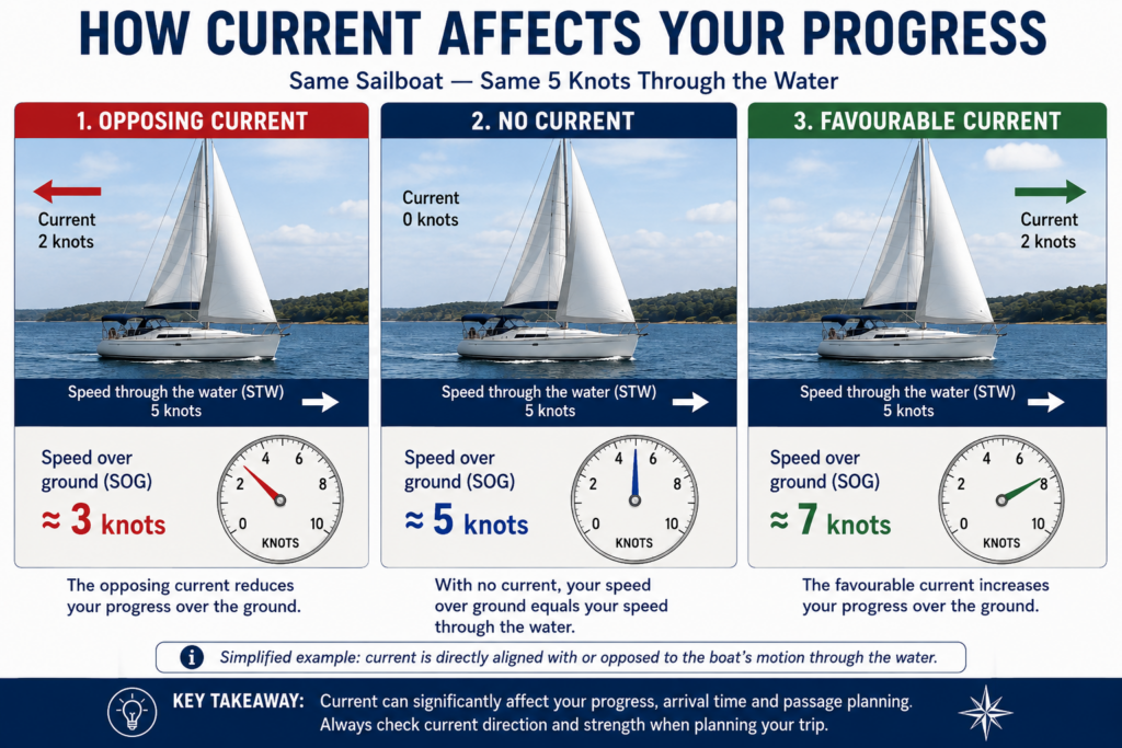
A boat sailing through the water at 5 knots against a 2-knot current may make only about 3 knots over the ground in the direction of that current.
With a 2-knot favorable current, the same 5-knot boat could make roughly 7 knots over the ground, assuming the current is aligned with the course.
That difference can transform the timing of a trip.
Current affects more than arrival time
Strong currents can also affect:
- steering
- harbour entrances
- narrow passages
- turning room
- navigation around hazards
- waves where wind opposes current
If significant currents exist along the route, determine when they run, approximately how strongly they run and in what direction.
Sometimes changing your departure by an hour can make a major difference.
Study the Nautical Chart
Now begin examining the route in detail.
A chart is not simply there to tell you which direction to steer.
It helps you understand the environment through which you intend to travel.
Look for:
- depths
- shoals
- rocks
- reefs
- wrecks and obstructions
- navigation aids
- channels
- restricted areas
- traffic routes
- cables and pipelines
- harbour entrances
- bridges
- prominent landmarks
- anchorages
- possible shelter
- alternate destinations
Before relying on a charted depth, make sure you understand the chart’s units and depth datum.
Also check relevant chart notes, cautions and publication information.
Do not plan directly along hazards
Beginners sometimes create routes that pass unnecessarily close to rocks, shoals or shorelines because the electronic chart makes precise navigation look easy.
GPS accuracy does not eliminate the need for margin.
Give hazards appropriate clearance.
A route with generous margins is usually easier to navigate and more forgiving of:
- steering errors
- current
- waves
- GPS or chart limitations
- unexpected traffic
- reduced visibility
Identify the Critical Parts of the Route
Not every mile of a passage deserves the same amount of attention.
Some sections are straightforward.
Others require much more planning.
These are sometimes useful to think of as critical points.
Examples include:
- narrow channels
- shallow passages
- exposed headlands
- strong-current areas
- ferry routes
- shipping lanes
- complicated harbour entrances
- bridges
- areas with limited escape options
For each critical area, ask:
What could make this section difficult?
Then determine what information you need before entering it.
Perhaps you need sufficient tide height.
Perhaps you want to arrive before the current strengthens.
Perhaps you want to cross a traffic route in good visibility.
Perhaps you want to round an exposed headland before the afternoon wind increases.
This is much more useful than treating every waypoint as equally important.
Identifying a hazard is only the beginning. The skipper must also consider how weather, current, visibility, traffic, available water, crew workload and escape options affect that hazard at the time the boat will encounter it.
A narrow channel in calm water may demand little attention. The same channel with an opposing current, building wind, commercial traffic and a tired crew creates a very different problem.
That deeper evaluation is covered in Route Hazards and Route Evaluation.
Measure the Distance
Once you have a reasonable route, determine its approximate length.
Sailing distances are normally expressed in nautical miles.
One nautical mile equals approximately 1.852 kilometers.
Do not simply measure a straight line from departure to destination if your actual route must go around islands, shoals or headlands.
Measure the route you realistically expect to travel.
Then consider something else:
A sailboat may not be able to sail directly toward the destination.
If the destination lies upwind, you may have to tack.
That means your actual distance through the water can be considerably longer than the direct chart distance.
Estimate How Long the Trip Will Take
A basic time estimate is:
Time = Distance ÷ Speed
Suppose your route is 20 nautical miles and you reasonably expect to average 5 knots.
20 ÷ 5 = 4 hours.
That gives you a starting estimate.
But do not confuse the calculation with reality.
Your average speed may be affected by:
- wind strength
- wind direction
- waves
- current
- tacking
- sail changes
- traffic
- maneuvering
- harbour entrances
- periods under engine
A beginner planning a coastal trip should generally favour a conservative speed estimate rather than assuming the boat will maintain its best cruising speed all day.
Build in margin
If the mathematical answer says four hours, do not automatically plan your entire day around arriving exactly four hours later.
Allow time for things to take longer.
Sailing frequently does.
That margin becomes especially important when arrival time affects tide, daylight or weather exposure.
Think About Daylight
Daylight is a resource.
Treat it like one.
Determine:
- sunrise
- sunset
- expected departure
- expected arrival
- remaining daylight at arrival
For beginners, arriving at an unfamiliar harbour for the first time after dark can add significant difficulty.
Navigation marks become harder to interpret.
Unlit hazards become harder to see.
Background lights can make navigation lights confusing.
Docking becomes more demanding.
Fatigue may also be greater after a long day.
Whenever practical, plan to arrive with comfortable daylight remaining, not merely minutes before sunset.
Watch for cascading delays
Suppose you expect to arrive at 1800 with sunset at 2030.
That seems comfortable.
But then:
- departure is 30 minutes late
- wind is lighter than expected
- an opposing current costs another 30 minutes
- you spend 20 minutes dealing with a sail problem
Suddenly the daylight margin has largely disappeared.
Good plans have enough flexibility to absorb ordinary delays.
Calculate Your Fuel Requirements
It may seem strange to discuss fuel in an article about sailing.
It shouldn’t.
For many coastal cruising sailboats, the engine is an important part of the safety and passage-planning picture.
You may need it for:
- leaving the marina
- entering harbour
- maneuvering in confined water
- periods of calm
- charging electrical systems
- dealing with an unexpected change of plan
Know approximately:
- your usable fuel capacity
- your engine’s typical fuel consumption
- the amount currently aboard
- the motoring time potentially required
- an appropriate reserve
Do not base your plan on using every usable liter or gallon.
A simple fuel calculation
If an engine consumes approximately 2 liters per hour and you might need to motor for 5 hours:
2 L/hour × 5 hours = 10 liters
But 10 liters should not automatically become the amount you depart with.
You still need a sensible reserve.
Actual consumption can vary with engine, RPM, conditions, loading and other factors, so use figures appropriate to your own boat.
Assess the Boat
A route can be reasonable while the boat is not ready for it.
Before a significant trip, consider whether the vessel is properly equipped and functioning.
Depending on the boat and voyage, check items such as:
- engine
- fuel
- batteries
- navigation lights
- bilge pumps
- steering
- rigging
- sails
- reefing equipment
- anchor and rode
- VHF radio
- navigation equipment
- required safety equipment
- freshwater
- appropriate tools and spares
The purpose is not to create the illusion that every possible failure can be prevented.
It cannot.
The purpose is to identify obvious problems before the dock lines come off.
Assess the Crew
A passage plan must fit the people aboard, not merely the boat.
Ask:
- How experienced is the crew?
- Has anyone sailed in these conditions before?
- Can someone else steer?
- Does anyone know how to use the VHF?
- Does the crew know where safety equipment is located?
- Is anyone likely to become seasick?
- Are children aboard?
- Is the trip unusually long for this crew?
- Will fatigue become an issue?
A trip that is comfortable for an experienced crew may be overwhelming for someone on their first sail.
That does not mean beginners should never make longer trips.
It means the skipper should account for the crew when deciding what constitutes a reasonable plan.
Crew capability should also affect which route you choose.
A route requiring repeated sail changes, a difficult ferry crossing, an exposed headland and a demanding harbour entrance may be reasonable for one crew and excessive for another — even aboard exactly the same boat in exactly the same weather.
Consider not only whether individual crew members have sailed before, but:
- which tasks they can perform without continuous instruction;
- whether another person can steer while the skipper handles a problem;
- whether someone can maintain an effective lookout;
- whether the crew can reef, handle lines or prepare for docking when conditions become demanding;
- whether seasickness, anxiety or fatigue could reduce capability later in the trip; and
- how much attention the skipper will need to devote to supervising the crew.
For a fuller framework, see How to Assess, Brief, and Manage a Crew.
Brief the crew
Before departure, everyone should understand the basic plan.
They should know:
- where you are going
- approximately how long it should take
- what conditions are expected
- important safety procedures
- where PFDs and emergency equipment are located
- what to do if someone falls overboard
- how to call for help if necessary
Plan Your Communications
A working communication system is part of passage planning.
For most coastal sailors, this means understanding how to use the boat’s VHF marine radio.
Before departure:
- confirm the radio works
- know the relevant calling and working channels
- understand emergency procedures
- know your vessel information
- ensure crew members can locate and operate the radio
- ensure handheld units are adequately charged if carried
A mobile phone can be useful, but it should not automatically be treated as a replacement for appropriate marine communication equipment.
Coverage can disappear.
Batteries fail.
Phones may become wet.
A properly used marine VHF provides capabilities designed specifically for communication on the water.
Always Have an Alternate Destination
One of the biggest upgrades in a beginner skipper’s thinking is moving away from:
“We’re going there.”
toward:
“That’s our intended destination, provided the conditions continue to support the plan.”
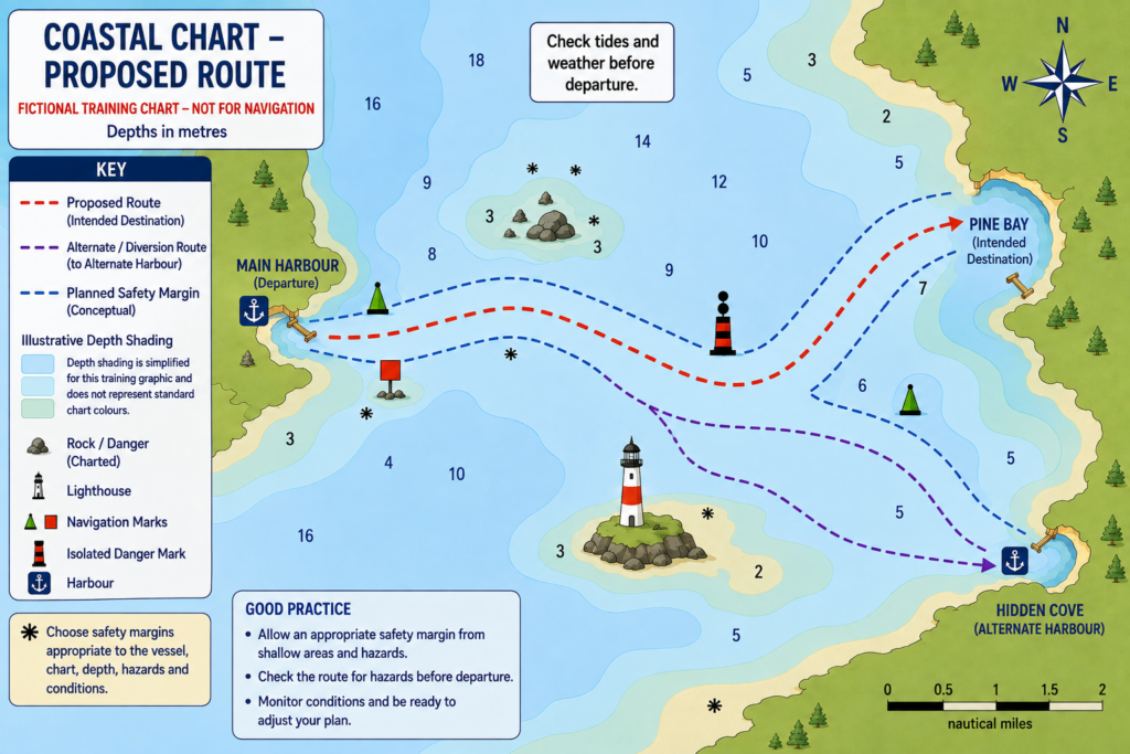
Choose at least one realistic alternative.
Perhaps there is another harbour halfway along the route.
Perhaps you can turn back.
Perhaps a protected anchorage offers shelter.
Perhaps the correct alternative is simply to stay at the dock.
Alternatives should be planned before you need them
Do not wait until conditions are deteriorating to begin searching the chart for somewhere else to go.
Know beforehand:
- where the alternate is
- how far away it is
- how to enter it
- whether depth is adequate
- whether it provides appropriate shelter
- whether there are hazards near the entrance
This reduces decision-making pressure when circumstances change.
An alternative becomes much more useful when you decide in advance what would cause you to use it.
It is not enough to know that another harbour exists.
Ask:
“What change would make me stop pursuing the primary plan and choose the alternative?”
That change might involve weather, sea state, progress, visibility, crew condition, equipment, current or remaining daylight.
Those conditions become your trigger points.
Establish Decision Points
A particularly useful habit is to decide in advance what conditions would cause you to reconsider the trip.
For example:
If we have not reached the headland by 1400, we turn back.
Or:
If the forecast update calls for winds above our comfort level, we use the alternate harbour.
Or:
If visibility deteriorates before the channel entrance, we do not continue through it.
These are sometimes called decision points, trigger points or turnaround criteria.
The terminology matters less than the thinking.
Decisions are often easier to make while sitting calmly at the dock than when tired, wet and already committed to a route.
Good trigger points protect options. If you wait until continuing has become obviously impossible, many of your easier alternatives may already have disappeared. The goal is to act while you still have useful choices — a principle explored more fully in Skipper Decision Making.
Understand the Danger of “Get-There-Itis”
One of the most dangerous pressures in recreational boating is the feeling that you must reach the planned destination.
Perhaps you have a reservation.
Perhaps friends are waiting.
Perhaps you already told everyone where you are going.
Perhaps turning around feels like failure.
None of those things changes the weather.
Good skippers change plans.
Sometimes the best passage ends at a completely different harbour.
Sometimes it ends back at the dock 30 minutes after departure.
And sometimes the best sailing decision of the day is never leaving.
Changing the plan because conditions no longer support it is not poor seamanship.
Continuing simply because the destination was written down can be.
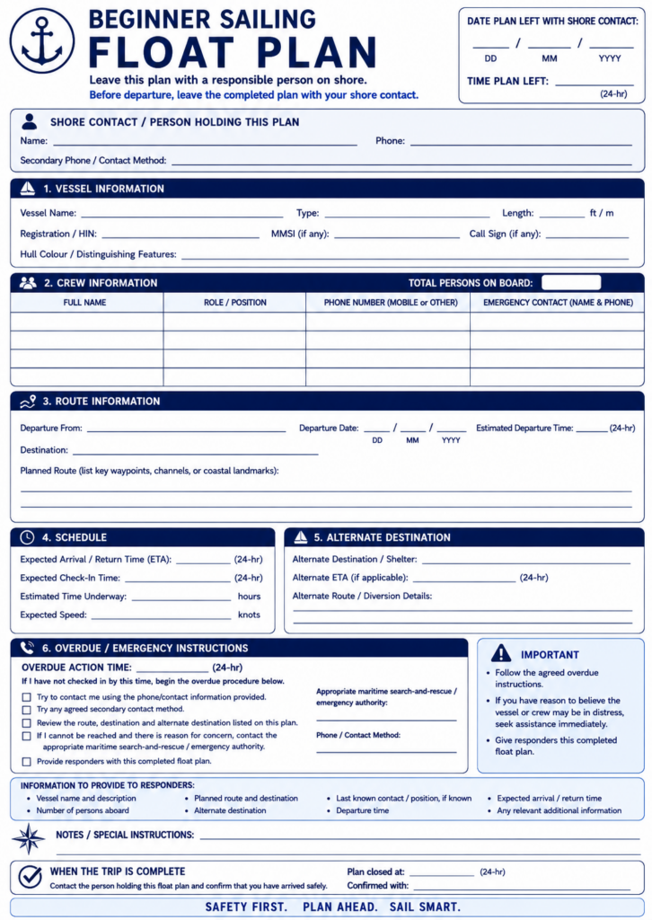
File a Float Plan
Before a significant recreational boating trip, make sure a responsible person ashore knows what you are doing.
This is commonly called a float plan or sail plan.
It should include enough information to help authorities if you fail to return or check in as expected.
Useful information includes:
- vessel name
- vessel description
- registration information where appropriate
- names or number of people aboard
- departure location
- destination
- intended route
- departure time
- expected arrival or return time
- alternate destinations
- communication information
- instructions for what to do if you are overdue
The person receiving the float plan needs to understand what you expect them to do.
Simply texting someone, “Going sailing today,” is not a useful float plan.
Remember to close the plan
When you arrive safely, notify the person holding your float plan.
Otherwise, the system doesn’t work very well.
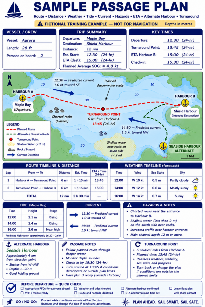
Put Everything Together: A Sample Sailing Trip
Now let’s combine the pieces.
Imagine you are planning a coastal day sail.
Your destination is 18 nautical miles away.
Your cruising sailboat normally averages about 5 knots in moderate conditions.
Step 1: Estimate travel time
18 NM ÷ 5 knots = approximately 3.6 hours.
Rather than assuming you will arrive in exactly 3 hours and 36 minutes, you plan on roughly four to five hours.
Step 2: Check weather
Morning winds are expected to be moderate, but the forecast calls for stronger winds later in the afternoon.
That matters because your return trip could occur during the stronger conditions.
Step 3: Check tide
The destination harbour has adequate depth throughout your expected arrival period, but a shallow section along the route deserves additional clearance near low water.
Step 4: Check current
A favorable current is expected during part of the outbound trip.
The return may involve an opposing current.
Your return time estimate therefore needs additional margin.
Step 5: Study the chart
You identify:
- one shoal
- a ferry crossing
- an exposed headland
- the destination harbour entrance
- a protected alternate harbour
Step 6: Check daylight
Sunset is 2030.
You want to be back well before then.
That produces an important planning decision:
You establish a turnaround time.
If progress is slower than expected, you will shorten the trip rather than allow the schedule to drift toward darkness.
Step 7: Check fuel
You have enough fuel to motor for the expected requirement plus an appropriate reserve.
Step 8: Assess the crew
The crew is comfortable with the expected conditions and has been briefed on:
- PFDs
- person-overboard response
- VHF operation
- route
- alternate destination
Step 9: Leave a float plan
Someone ashore knows your intended route and expected return time.
Now you have something much more useful than a line on a chart.
You have a passage plan.
The Plan Continues After You Leave
A passage plan is not finished when you untie the dock lines.
Once underway, compare reality with what you expected.
Ask periodically:
- Is the wind doing what was forecast?
- Are we making the expected speed?
- Are we on schedule?
- Has the sea state changed?
- Is visibility deteriorating?
- Is the crew still comfortable?
- Are we using more fuel than expected?
- Has the forecast changed?
- Is the alternate still practical?
- Do we still have sufficient daylight margin?
This is sometimes described as monitoring the passage.
It is one of the most important habits you can develop.
Compare planned progress with actual progress
Suppose you expected to reach a headland at 1300.
At 1300, you are still six miles away.
That difference is information.
Do not simply say:
“We’re running late.”
Ask:
Why?
Perhaps the current is stronger than expected.
Perhaps the wind is lighter.
Perhaps the sea state is slowing the boat.
Whatever the reason, your original arrival estimate may no longer be valid.
Update the plan.
Use Your Electronics — But Keep Thinking
Modern chartplotters and navigation apps are extraordinarily useful.
They can display:
- position
- course
- speed over ground
- waypoints
- routes
- distance remaining
- estimated arrival time
- chart information
- AIS targets on suitably equipped systems
- tides and currents on some systems
Use those tools.
But understand what they are telling you.
A chartplotter can calculate an ETA.
It cannot decide whether arriving at that time is sensible.
It can draw a route.
It cannot guarantee that the route is appropriate for your vessel.
It can show your position extremely precisely on a chart whose underlying information may have limitations.
Electronic navigation should strengthen seamanship, not replace it.
Common Sailing Trip Planning Mistakes
Mistake 1: Planning only the destination
Problem: The skipper decides where to go but doesn’t adequately consider the return.
Correction: Plan the entire trip, including return conditions and alternatives.
Mistake 2: Looking only at wind speed
Problem: Direction, gusts, waves and forecast changes are ignored.
Correction: Read the complete marine forecast and consider how conditions evolve over time.
Mistake 3: Ignoring current
Problem: Distance and boat speed suggest an easy trip, but opposing current significantly delays progress.
Correction: Check current direction and strength where relevant.
Mistake 4: Using straight-line distance
Problem: The actual route around hazards or while sailing upwind is much longer.
Correction: Measure the realistic navigable route.
Mistake 5: Planning to arrive at sunset
Problem: Even a small delay produces a nighttime arrival.
Correction: Maintain a meaningful daylight margin.
Mistake 6: No alternate destination
Problem: When conditions deteriorate, the crew has to improvise.
Correction: Identify practical alternatives before departure.
Mistake 7: Overestimating boat speed
Problem: The entire schedule assumes ideal performance.
Correction: Use conservative average speeds and allow extra time.
Mistake 8: Forgetting fuel because it is a sailboat
Problem: The engine becomes necessary and fuel is insufficient.
Correction: Estimate possible motoring requirements and carry an appropriate reserve.
Mistake 9: Ignoring crew capability
Problem: The boat can handle the conditions, but the people aboard cannot comfortably manage them.
Correction: Plan for the actual crew.
Mistake 10: Treating the plan as a commitment
Problem: Conditions change, but the skipper continues because reaching the destination has become the goal.
Correction: Treat the passage plan as something that should be continuously reassessed.
A Beginner Sailing Trip Planning Checklist
Route
- Choose the intended destination
- Identify the departure point
- Study the complete route
- Measure realistic distance
- Identify major hazards
- Identify critical sections
- Choose an alternate destination
- Establish turnaround or decision points
- Evaluate how hazards interact with weather, current and traffic
- Identify where escape options become limited
Weather
- Check the marine forecast
- Check wind direction
- Check sustained wind speed
- Check gusts
- Check waves or sea state
- Check visibility
- Check for warnings, fronts or thunderstorms
- Note expected changes during the trip
Tide and Current
- Check tide predictions
- Determine expected water levels at critical locations
- Check tidal currents where relevant
- Consider current when estimating travel time
- Consider wind-against-current conditions
Time and Daylight
- Estimate passage time
- Use a conservative average speed
- Allow for delays
- Check sunset
- Maintain adequate daylight margin
Boat
- Check fuel
- Allow an appropriate fuel reserve
- Check engine
- Check sails and rigging
- Check reefing equipment
- Check steering
- Check navigation equipment
- Check safety equipment
- Check anchor and rode
- Check navigation lights
Crew and Communications
- Assess crew experience
- Brief the crew on the route
- Review emergency procedures
- Confirm pads and safety equipment
- Check VHF operation
- Make sure another crew member can use the radio
- Match route demands to actual crew capability
- Identify tasks the skipper would have to perform personally
Before Departure
- Leave a float plan
- Recheck weather
- Confirm tide/current timing
- Confirm fuel
- Confirm primary route, realistic alternatives and the trigger for using each
- Make the final go/no-go decision
Underway
- Monitor weather
- Monitor actual versus planned progress
- Monitor crew condition
- Monitor fuel if motoring
- Recalculate ETA when necessary
- Reassess the destination and alternatives
- Change the plan when conditions warrant it
- Ask whether options are increasing or disappearing
The Final Go/No-Go Decision
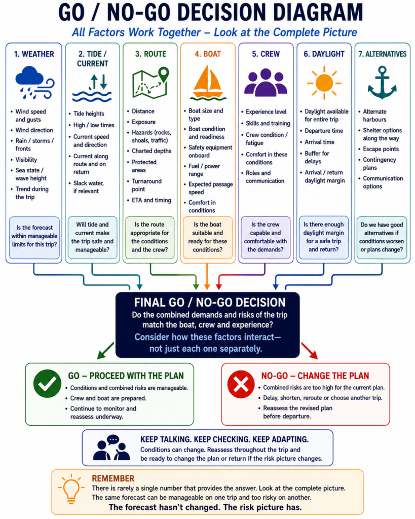
Eventually, planning reaches a point where you have to decide:
Do we leave?
There is rarely a single number that provides the answer.
Instead, look at the complete picture.
Perhaps the weather is slightly stronger than ideal, but the route is protected, the crew is experienced and several alternate harbors are available.
That may be manageable.
Now change the situation.
The same wind is forecast, but the route crosses exposed water, the crew is inexperienced, the return will be against a strong current and the trip leaves little daylight margin.
The forecast hasn’t changed.
The risk picture has.
This is why skipper decisions cannot be reduced to rules such as:
“Never sail above X knots.”
Conditions interact.
The question is whether the combined demands of the trip are appropriate for your boat, your crew and your experience.
Know When to Make the Trip Easier
There is another option between completing the original plan and canceling sailing entirely.
Make the trip easier.
You might:
- choose a closer destination
- stay in protected water
- depart earlier
- wait for a more favorable current
- shorten the trip
- avoid an exposed section
- choose a harbour with an easier entrance
- return before the weather deteriorates
This is an important part of developing judgment.
The objective is not to prove that you can complete the most ambitious version of the trip.
The objective is to have a safe, manageable day on the water while gradually expanding your experience.
From Sailor to Skipper
Earlier sailing lessons often have relatively clear answers.
Which way should I turn the tiller?
When should I reef?
Which boat is on starboard tack?
How do I read this depth on the chart?
Passage planning is different.
Now several correct pieces of information must be combined into a decision.
The forecast may be acceptable.
The tide may be acceptable.
The boat may be capable.
The distance may be reasonable.
Yet when you combine an inexperienced crew, an opposing current, a late departure and an unfamiliar harbour entrance near sunset, the overall plan may still be poor.
That is the larger lesson.
Skipper decisions are made from the whole situation, not one favorable piece of information.
Learning individual sailing skills makes you more capable of operating the boat.
Learning to combine those skills into sound decisions is what begins to make you a skipper.
Key Takeaways
A good sailing trip plan considers the entire voyage rather than simply the destination.
Before departure, evaluate:
- weather
- tide
- current
- charts and hazards
- realistic distance
- expected travel time
- daylight
- fuel
- boat readiness
- crew capability
- communications
- alternate destinations
- emergency options
- float-plan information
Most importantly, continue evaluating the plan after departure.
A passage plan is not a promise about what you are going to do.
It is your best assessment of what should work based on the information available.
When the information changes, the plan should be allowed to change with it.
Beginner Knowledge Check
1. Why is measuring a straight line between departure and destination sometimes misleading?
A. Nautical charts distort all distances
B. Sailboats always travel in circles
C. Hazards, coastlines, currents and upwind sailing may make the actual route longer
D. GPS distance is always inaccurate
2. Your boat travels at 5 knots through the water directly against a 2-knot current. Approximately how quickly is it progressing over the ground in that direction?
A. 2 knots
B. 3 knots
C. 5 knots
D. 7 knots
3. Why should you check the forecast for the entire expected duration of the trip?
A. Marine forecasts are only valid for one hour
B. Conditions may change substantially before the return passage
C. Wind always increases during the afternoon
D. Tide predictions depend on wind forecasts
4. What is the primary purpose of an alternate destination?
A. To make the route longer
B. To provide another practical option if the original plan becomes unsuitable
C. To improve GPS accuracy
D. To reduce fuel consumption
5. Why is planning to arrive immediately before sunset generally poor practice for a beginner?
A. Sailing after noon is prohibited
B. Winds always stop at sunset
C. Small delays can turn the arrival into a nighttime approach
D. GPS stops working after sunset
6. Which is the best approach to estimating passage time?
A. Assume maximum hull speed
B. Use the boat’s fastest speed from a previous sail
C. Use a realistic conservative average and include margin
D. Divide distance by wind speed
7. Why should a sailing vessel consider fuel during passage planning?
A. Sails require fuel
B. The engine may be required for maneuvering, calm conditions or a change of plan
C. Fuel affects tidal height
D. Sailboats are legally required to motor part of every trip
8. What should happen to a passage plan once the boat leaves the dock?
A. Nothing; it should never change
B. It should be continuously compared with actual conditions and progress
C. It should be deleted from the chartplotter
D. It should only be reconsidered during an emergency
9. Which is the best example of a predetermined decision point?
A. “We’ll see what happens.”
B. “We really want to reach the destination.”
C. “If we haven’t reached the headland by 1400, we’ll turn back.”
D. “We’ll sail until someone becomes uncomfortable.”
10. What is the central lesson of passage planning?
A. Follow the shortest possible route
B. Electronics can make most decisions for you
C. Combine multiple sources of information to decide whether the trip remains sensible
D. Never change a route after departure
Answer Key
1. C — The actual sailing route may need to avoid hazards, follow channels or zigzag when sailing upwind.
2. B — Approximately 5 knots through the water minus a directly opposing 2-knot current gives about 3 knots over the ground in this simplified example.
3. B — Conditions later in the trip may be very different from conditions at departure.
4. B — An alternate gives you a practical option if weather, timing, crew condition or another factor makes the original destination undesirable.
5. C — Normal delays can quickly turn a daylight arrival into a nighttime approach.
6. C — Conservative estimates and additional margin produce more useful passage plans.
7. B — Even on a sailboat, the engine may become important during harbour maneuvering, calm conditions or changes to the original plan.
8. B — The plan should be monitored and updated as conditions and actual progress become known.
9. C — A specific time and location provide a clear point at which the skipper reassesses the plan.
10. C — Passage planning is fundamentally about integrating weather, navigation, tide, current, time, boat, crew and other information into sound decisions.