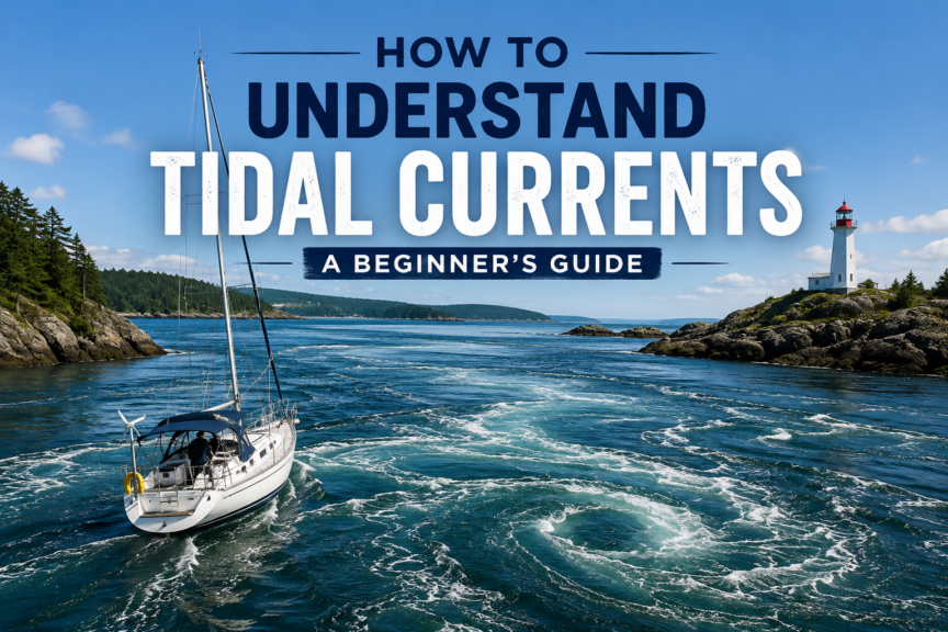
Tidal currents are one of those parts of sailing that can seem mysterious until you understand what the water is actually doing.
You may leave the marina with a comfortable breeze, point the boat toward your destination, and discover that your GPS track is slowly sliding sideways. On another day, the same boat on what seems like the same route may arrive surprisingly quickly. At the entrance to a narrow channel, calm-looking water may suddenly turn into ripples, swirls, standing waves, or fast-moving streams.
In all of these situations, tidal current may be responsible.
For a beginner sailor, understanding tidal currents is not about becoming an expert navigator overnight. It is about learning to answer a few practical questions:
- Which way is the water moving?
- How fast is it moving?
- When will it change?
- Will it help or hinder my boat?
- Could the current make conditions more difficult?
- Is there a better time to make this passage?
Once you can answer those questions, tidal currents become much less mysterious.
They also become useful.
Experienced sailors don’t always fight the current. Whenever possible, they plan around it and use it to their advantage.
About this Guide
Written by Kelly Hiebert, a recreational sailor since 2002 and a middle-school teacher. Kelly created Sailboat Zone to provide beginners with clear, structured sailing education.
Last reviewed: September 2026
Jurisdiction: This guide explains general tidal-current principles and passage-planning concepts, using Canadian Hydrographic Service information as its primary reference. Current timing, direction and strength can vary greatly over short distances and may differ from tide-height timing. Always use current official predictions for the correct station, date and time reference, together with applicable charts, current atlases and local navigation information.
Primary sources:
- Canadian Hydrographic Service — Current Predictions by Station
- Canadian Hydrographic Service — Canadian Tide and Current Tables
- Canadian Hydrographic Service — Canadian Atlas of Tidal Currents
Safety note: Tidal-current predictions are planning tools, not guarantees of the conditions you will encounter. Confirm the correct station, date, time reference and direction convention; consult current charts, tide and current tables, applicable current atlases and Sailing Directions; and compare predictions with weather and direct observation. Avoid narrow passes or strong-current areas when the predicted or observed conditions exceed the abilities of the boat or crew.
What Is a Tidal Current?
A tide is usually easiest to notice as a change in water level.
Visit a dock at high tide and then return several hours later at low tide, and the difference may be obvious.
But all that water doesn’t simply move vertically.
As the tide rises and falls, enormous quantities of water move horizontally through bays, channels, straits, harbour entrances, around islands, and along coastlines.
That horizontal movement of water is what we call a tidal current.
This distinction is fundamental:
Tide describes the rise and fall of water level.
Tidal current describes the horizontal movement of that water.
The two are connected, but they are not interchangeable.
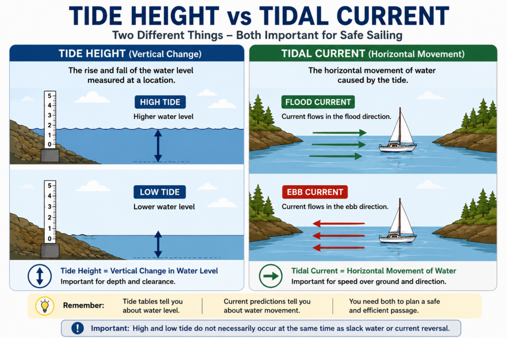
If you haven’t already learned how tidal heights are predicted, read our guide to How to Read Tide Tables first. Understanding tide tables makes tidal-current predictions considerably easier to interpret.
Why Tidal Currents Matter to Sailors
Imagine your sailboat can travel at about 5 knots through the water.
Now imagine the water itself is moving at 2 knots.
That moving water can significantly change where your boat goes and how quickly it gets there.
A favorable current can shorten a passage.
An opposing current can dramatically lengthen it.
A cross-current can carry you sideways.
A strong enough adverse current can even prevent a slow sailboat from making progress over the seabed.
Currents can also affect:
- docking
- anchoring
- harbour entrances
- narrow passages
- steering
- passage times
- fuel consumption
- sea conditions
- navigation around hazards
Understanding current therefore isn’t just a navigation skill.
It is part of basic seamanship.
Flood, Ebb and Slack Water
Three words appear constantly in tidal-current information:
Flood. Ebb. Slack.
Understanding them gives you the foundation for almost everything else in this article.
A flood current generally occurs when tidal water is moving into an area as the tide rises.
An ebb current generally occurs when tidal water is moving out as the tide falls.
Between them comes slack water.
Slack water is the period around a current reversal when the speed of the current becomes very low before beginning to flow in the opposite direction.
A simplified cycle might look like this:
Slack → Flood strengthens → Maximum flood → Flood weakens → Slack → Ebb strengthens → Maximum ebb → Ebb weakens → Slack
Then the cycle begins again.
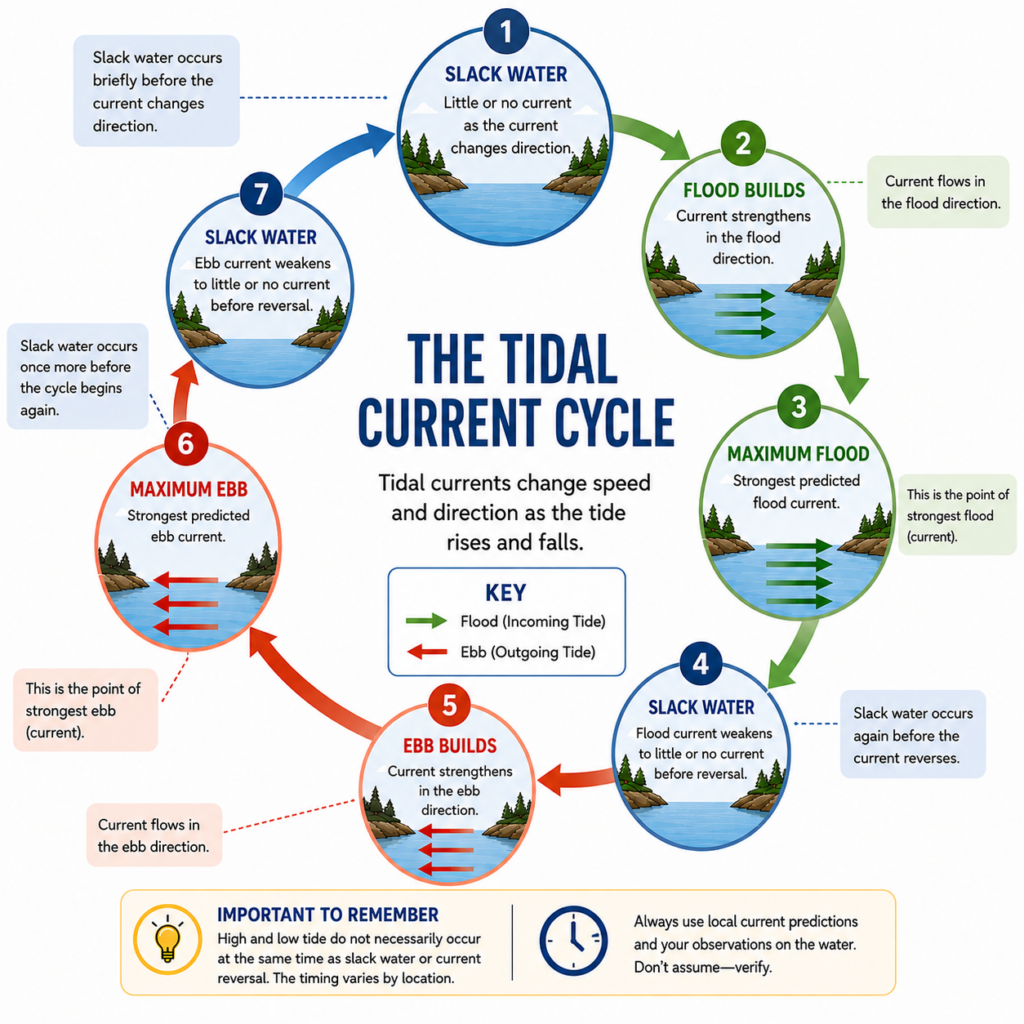
One important point is that slack water does not necessarily last very long.
In some locations, particularly areas with strong tidal currents, the transition can happen relatively quickly.
That makes accurate timing important when sailors plan to transit narrow passages or other areas where strong currents can create difficult conditions.
High Tide Does Not Necessarily Mean Slack Water
This is one of the most important lessons in the entire article.
A beginner might reasonably assume:
“High tide is at 2:00 p.m., so the current should stop and reverse at 2:00 p.m.”
That sounds logical.
Unfortunately, it isn’t necessarily true.
The time of high or low water at a tide station and the time of slack current at a nearby current station can be different.
Local geography matters enormously.
Water moving through a complicated network of channels, bays, islands and straits doesn’t instantly stop because a particular tide station has reached high water.
Therefore:
Never assume that high tide equals slack water.
And:
Never assume that low tide equals slack water.
If current timing matters to your passage, use appropriate tidal-current predictions for the area.
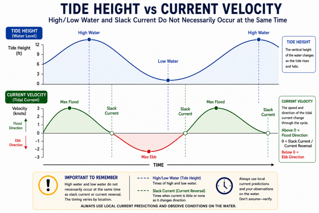
This distinction is especially important in places with complicated coastal geography.
Understanding Current Direction
Current has both speed and direction.
Direction tells you where the water is flowing.
This can initially cause confusion because wind and current are often described differently.
When sailors say there is a west wind, they normally mean the wind is coming from the west.
Current direction, however, describes the direction toward which the water is moving.
So a current setting west is carrying water toward the west.
This difference is worth remembering.
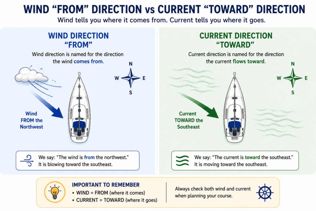
Flood and ebb also don’t tell you a compass direction by themselves.
A flood current might flow north through one channel, east through another, and southeast around a nearby island.
The shape of the coastline determines where the water can go.
That is why current arrows and local current predictions are so useful.
Understanding Current Speed
Tidal-current velocity is normally expressed in knots.
One knot equals one nautical mile per hour.
A 1-knot current may not sound particularly impressive, but to a sailboat traveling at only 4 or 5 knots, it is significant.
A 2-knot current is even more important.
A 4-knot current can dominate the movement of a slow boat.
As a rough way of appreciating the effect:
| Current Speed | Practical Effect |
|---|---|
| 0–0.5 knots | Usually relatively weak |
| 0.5–1 knot | Noticeable to a small sailboat |
| 1–2 knots | Significant for passage planning |
| 2–3 knots | Strong current |
| 3+ knots | Potentially demanding conditions |
These are not safety limits.
A 1-knot current in the wrong location can be more consequential than a faster current in open water.
Depth, waves, wind, traffic, rocks, channel width and boat speed all matter.
Boat Speed Through the Water vs Speed Over Ground
This is where tidal-current theory becomes very practical.
Suppose your sailboat is traveling through the water at:
5 knots
If the current is flowing in exactly the same direction at:
2 knots
your approximate speed over the seabed could be:
5 + 2 = 7 knots
Your boat still moves through the surrounding water at 5 knots, but that entire body of water is moving with you.
Now turn the situation around.
Your boat travels through the water at 5 knots, but the current flows directly against you at 2 knots.
Your approximate speed over ground becomes:
5 − 2 = 3 knots
The difference is enormous.
Over a 15-nautical-mile passage:
At 7 knots, the simplified travel time is about 2 hours 9 minutes.
At 3 knots, it becomes 5 hours.
Same boat.
Same distance.
Very different passage.
Can Current Actually Push a Sailboat Backward?
Yes.
Imagine a small sailboat making 3 knots through the water against a 4-knot current.
Relative to the surrounding water, the boat is moving forward.
Relative to the seabed, however, the water is carrying the boat backward faster than the boat can travel forward.
The approximate result is:
3 knots boat speed − 4 knots current = 1 knot backward over the ground.
From aboard the boat, the sails may be drawing and water may be flowing normally past the hull.
Yet a GPS or fixed landmark could reveal that you are actually moving backward.
This is one reason strong-current areas deserve considerable respect.
Current Can Also Push You Sideways
Currents rarely line up perfectly with the direction we want to travel.
Often they cross our intended course.
Imagine pointing your bow directly toward a lighthouse on the opposite side of a channel.
If a strong current is flowing from left to right, the boat will move forward through the water while the moving water carries the entire boat sideways.
Your actual path over the seabed becomes diagonal.
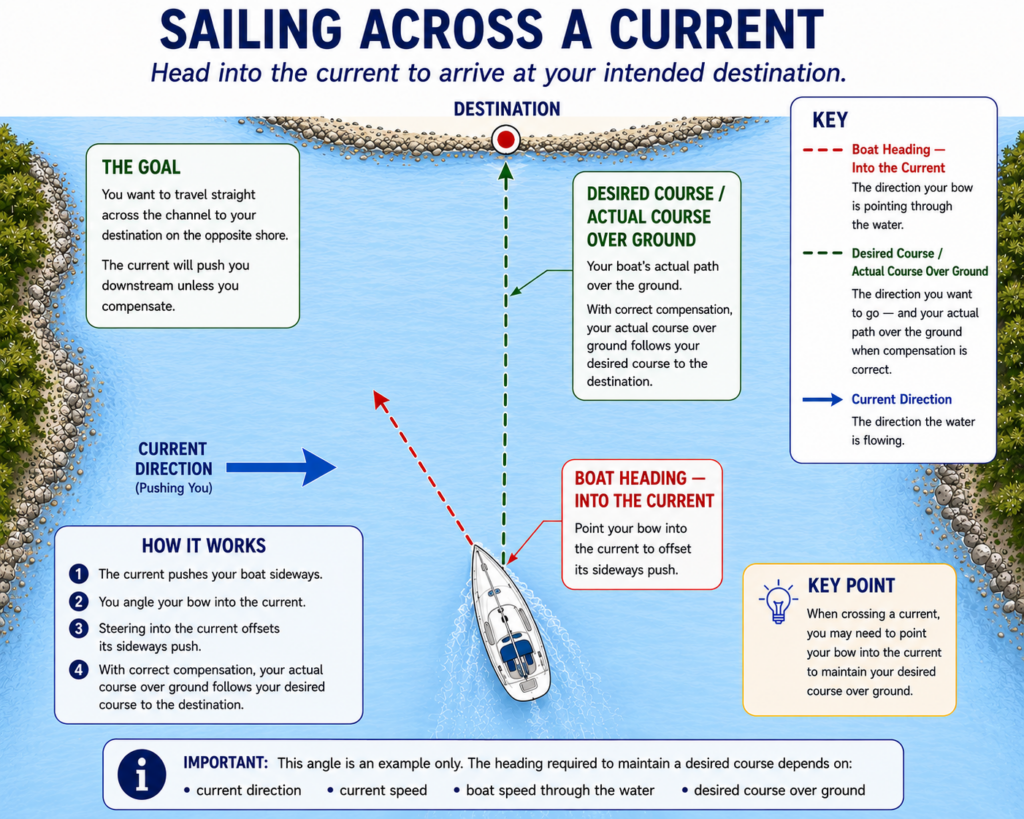
This introduces two useful navigation terms:
Set is the direction toward which the current carries you.
Drift, or rate, describes how fast it carries you.
Together, set and drift describe the effect of current on your vessel.
Later, as your navigation skills develop, you’ll learn to calculate these effects more precisely. For beginner sailing, the important lesson is simply this:
Where your bow is pointing and where your boat is actually traveling may not be the same thing.
Heading vs Course Over Ground
Modern GPS units and chartplotters make this difference easier to see.
Your heading is approximately where the bow is pointing.
Your course over ground, often abbreviated COG, describes the direction your boat is actually traveling across the Earth’s surface.
With no significant current or leeway, those may be similar.
With a strong cross-current, they can be noticeably different.
Your bow might point northwest while your GPS track shows the boat traveling north.
That difference is useful information.
It tells you that another force is affecting the boat.
Electronics can help you observe this effect, but they don’t replace understanding what is happening.
How Current Changes During the Tidal Cycle
Tidal current generally doesn’t switch instantly from maximum flow in one direction to maximum flow in the other.
Instead, current normally builds and weakens through a cycle.
A simplified progression is:
Slack water
↓
Current begins flowing
↓
Current strengthens
↓
Maximum current
↓
Current weakens
↓
Slack water
↓
Current reverses
The actual timing and shape of this cycle depend on the location.
This is why knowing only the maximum current isn’t enough.
If a prediction says maximum ebb is 3 knots, that doesn’t mean you will experience exactly 3 knots throughout the entire ebb period.
The Rule of Thirds — Useful, but Only as an Approximation
Sailors sometimes use simple rules of thumb to estimate how tidal current may build and decline between slack water and maximum current.
These approximations can be useful for learning and rough planning.
However, real tidal-current behavior is determined by local geography and hydrodynamics.
Some locations have relatively smooth current curves.
Others don’t.
Narrow passes and complicated waterways can behave quite differently from the simple textbook model.
For that reason, use official local current predictions whenever current strength or timing is important.
A rule of thumb is a planning aid, not a substitute for actual predictions.
Why Geography Makes Tidal Currents Stronger
Imagine pouring water through a wide opening.
Now force the same flow through a much narrower opening.
The water has to move faster through the constriction.
Coastal geography can produce a similar effect.
Large quantities of tidal water may need to move through:
- narrow channels
- straits
- passes
- harbour entrances
- gaps between islands
- areas around headlands
The result can be powerful currents.
This is why you cannot assume that current conditions will be similar everywhere in the same region.
A broad bay may have modest current while a nearby narrow passage experiences several knots.
Currents Around Islands and Headlands
Water doesn’t always flow neatly in a straight line.
When moving water encounters an island, headland, shoal or other obstruction, it must move around it.
This can create:
- accelerated flow
- eddies
- countercurrents
- current shadows
- turbulent water
- current seams
- boils
- whirlpool-like circulation
An eddy is an area where water circulates differently from the main current.
Sometimes an eddy may even flow opposite to the main stream.
Experienced local sailors may sometimes use favorable eddies to reduce the effect of an opposing current.
For a beginner, the more important lesson is simply to recognize that current does not behave uniformly around land.
Tide Rips, Overfalls and Standing Waves
Strong current can sometimes make the surface of the water look surprisingly rough.
You may encounter:
Current rips — rough or disturbed areas where currents interact.
Overfalls — turbulent water often associated with strong current flowing over uneven or shallow seabeds.
Standing waves — waves that appear relatively fixed in position because of strong current.
Boils and whirlpools — rotating or upwelling water caused by turbulence.
Conditions can become particularly noticeable near narrow passes, shoals and headlands.
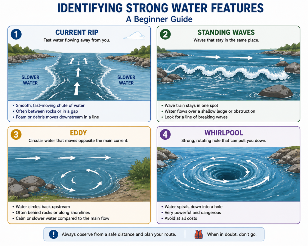
If the water ahead looks dramatically different from the water around you, don’t assume it is meaningless.
Observe it.
Slow down your decision-making.
Check the chart and current information.
There may be a reason the water looks different.
Wind Against Current
This is one of the most important tidal-current safety concepts.
Imagine waves traveling in the same general direction as the current.
The moving water can effectively lengthen the waves and make them feel less steep.
Now reverse the current.
The waves encounter water moving toward them.
They can become:
- shorter
- steeper
- closer together
- more likely to break
This is known as wind against current.
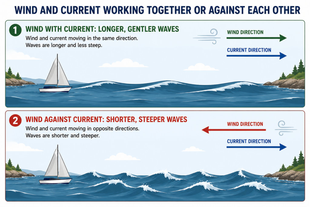
A channel that was comfortable earlier in the day may become considerably rougher after the current reverses, even if the wind hasn’t changed very much.
This is why checking the wind forecast alone isn’t enough when sailing in strong tidal-current areas.
Reading Tidal-Current Predictions
Once you understand the terminology, current predictions become much easier to interpret.
Depending on the source and location, you may see information such as:
- current station
- date
- time
- slack water
- maximum flood
- flood velocity
- maximum ebb
- ebb velocity
- flood direction
- ebb direction
Always verify:
Which station are you looking at?
What date are you looking at?
What time zone is being used?
Are daylight-saving adjustments already included?
Is this a reference station or a subordinate station?
For Canadian waters, an important official source is the Canadian Hydrographic Service (CHS).
When navigational decisions depend on tidal information, favor official or authoritative sources rather than relying blindly on an unidentified number displayed by an app.
Tide Tables and Current Predictions Work Together
Suppose you’re planning to sail through a shallow channel.
You may need to answer two completely different questions.
First:
Will there be enough water beneath my keel?
For that, tide height matters.
Second:
How quickly and in which direction will the water be moving?
For that, current predictions matter.
You need both pieces of information.
This is particularly important around shallow bars, harbour entrances and narrow channels.
Planning a Passage Around Tidal Current
Good tidal planning doesn’t need to be complicated.
Start with a simple process.
Step 1: Identify your route.
Look at where you are starting, where you’re going and what lies between.
Step 2: Check tide heights.
Determine whether depth will be an issue.
Step 3: Identify relevant current stations.
Look for predictions that apply to your route.
Step 4: Check flood, ebb and slack times.
Determine what the current should be doing during your passage.
Step 5: Check current direction.
Will it help you, oppose you or cross your route?
Step 6: Check predicted strength.
Compare the current with your realistic boat speed.
Step 7: Look for constrictions.
Identify narrow channels, harbour entrances, headlands and other locations where current may accelerate.
Step 8: Check the wind.
Pay particular attention to the possibility of wind against current.
Step 9: Estimate your arrival time.
Conditions may be different when you reach a tidal gate two hours from now.
Step 10: Consider alternatives.
Could leaving earlier or later produce a much easier passage?
Use your nautical chart to identify constrictions, hazards and safe alternatives before choosing a departure time.
Using Tidal Current to Your Advantage
Tidal current isn’t merely an obstacle.
It can be enormously helpful.
Imagine a 20-nautical-mile passage.
Your sailboat averages 5 knots through the water.
Without current, the simplified passage takes:
20 ÷ 5 = 4 hours
With a favorable 2-knot current for much of the route, your speed over ground could sometimes approach 7 knots.
That could significantly shorten the trip.
The opposite is also true.
With a 2-knot adverse current, your speed over ground could drop toward 3 knots.
Instead of simply accepting that penalty, a sailor may be able to alter the departure time and travel with more favorable water.
That is one of the fundamental ideas behind tidal passage planning:
Don’t automatically fight the tide if waiting can make the passage easier.
A Worked Beginner Example
Suppose you want to sail 15 nautical miles along the coast.
Your boat averages approximately:
5 knots through the water.
Current predictions indicate approximately:
2 knots flowing toward your destination.
Ignoring other variables for this simplified example:
5 + 2 = 7 knots SOG
Estimated travel time:
15 ÷ 7 ≈ 2.14 hours
That’s approximately 2 hours 9 minutes.
Now imagine making the same passage against the current:
5 − 2 = 3 knots SOG
Travel time:
15 ÷ 3 = 5 hours
That’s nearly three additional hours.
Of course, real currents change during the tidal cycle and rarely remain perfectly aligned with your course.
But the example shows why tidal planning matters.
Crossing a Strong Current
Sometimes the current isn’t helping or opposing you.
It is crossing your route.
Imagine crossing a channel while the water flows strongly from north to south.
If you simply point directly at your destination, the current may carry you south while you cross.
Instead, you may need to steer somewhat into the current.
The boat travels diagonally through the moving water while the current carries it sideways.
The combination can produce a course over ground toward your intended destination.
The exact heading required depends on:
- boat speed
- current speed
- current direction
- desired course
For beginners, the important principle is:
Aim based on where the boat is actually traveling, not simply where the bow is pointing.
Navigating Narrow Passes
Narrow passages deserve additional respect because several challenges can occur simultaneously.
You may encounter:
- stronger current
- turbulent water
- eddies
- standing waves
- limited maneuvering room
- rocks
- shorelines
- commercial traffic
- recreational traffic
- wind-against-current conditions
If the current approaches or exceeds your boat’s practical speed, your options may become very limited.
This is why experienced sailors often time difficult tidal passages carefully.
A narrow passage may be manageable near an appropriate current window and considerably more demanding a few hours later.
Beginners should be conservative.
There is nothing embarrassing about waiting.
Waiting for better conditions is often excellent seamanship.
How to Recognize Current on the Water
Predictions tell you what should happen.
Observation tells you what is happening.
Look for clues.
Buoys Leaning
A buoy leaning or trailing strongly downstream can reveal both current direction and strength.
Water Streaming Past Pilings
Dock pilings, bridge supports and navigation markers provide excellent visual references.
Foam Lines
Foam or debris may collect along current seams.
Eddies
Watch for circular movement behind islands, rocks, pilings and headlands.
Standing Waves
Waves that remain in roughly the same location can indicate strong current.
Different Water Textures
Smooth water beside rippled or turbulent water may mark a current boundary.
Floating Debris
Leaves, seaweed, driftwood or foam can reveal the actual movement of surface water.
Your GPS Track
If your heading and course over ground differ significantly, current may be contributing.
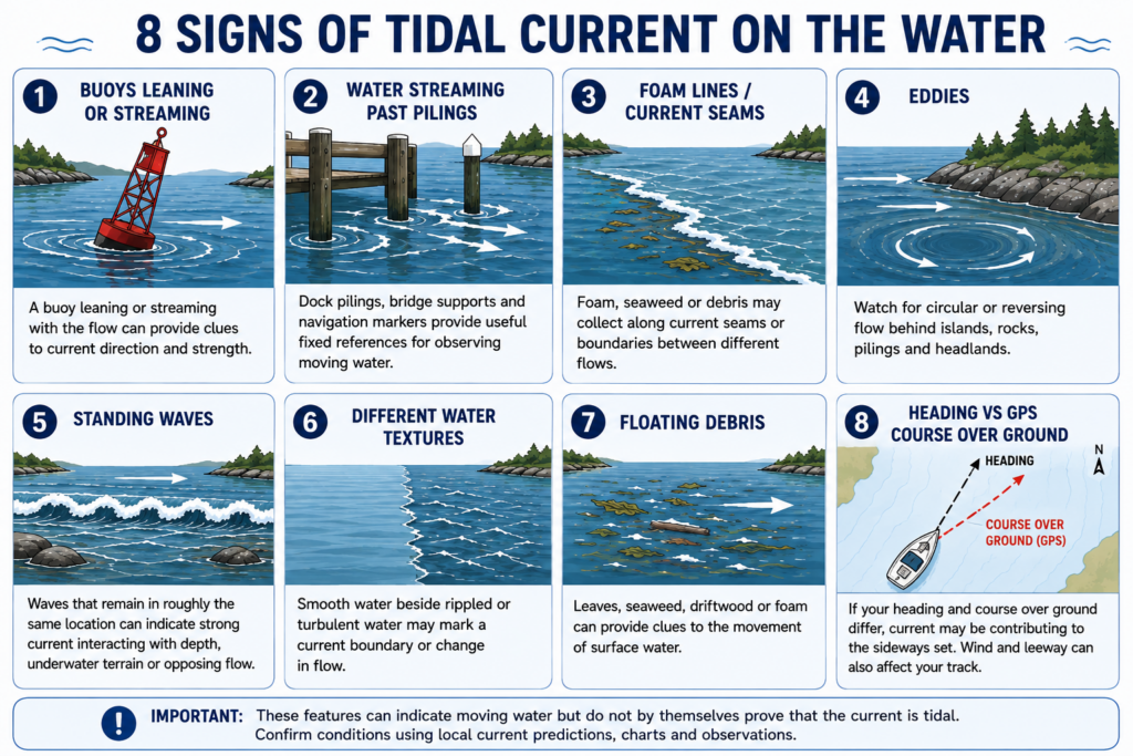
Learning to read these clues helps turn tidal current from an abstract number into something you can actually see.
Tidal Current Near Docks and Marinas
Current matters long before you reach open water.
It can have a major effect while docking.
A current running parallel to a dock may carry the boat forward or backward.
A cross-current may push the boat away from or toward the berth.
Current flowing through a marina entrance may affect the boat just as you make a turn.
Unlike wind, which acts primarily on the parts of the boat above the waterline, current acts on the hull, keel and rudder beneath the surface.
Sometimes wind dominates.
Sometimes current dominates.
Sometimes they oppose each other.
Before committing to a docking approach, observe:
- nearby buoys
- pilings
- floating debris
- other boats
- water movement around docks
Try to determine what the water is doing before you need to react to it.
For a full close-quarters procedure, see How to Dock a Sailboat.
Tidal Current and Anchoring
Current also affects an anchored boat.
When current flows past the hull, it creates force on the boat and ultimately on the anchor and rode.
When the current reverses, the boat may swing around the anchor.
That can create an interesting situation in an anchorage.
One boat may be influenced primarily by current.
Another may be influenced more strongly by wind.
Boats with different hulls, keels and rode arrangements may therefore lie at somewhat different angles.
When choosing an anchoring position in tidal waters, think beyond the conditions you see at the moment.
Ask:
Where will this boat be when the current reverses?
Common Tidal-Current Mistakes Beginners Make
Understanding a few common mistakes can prevent a surprising number of problems.
Mistake 1: Assuming high tide means slack water.
It may not.
Mistake 2: Confusing tide height with current speed.
They describe different things.
Mistake 3: Ignoring a 1-knot current.
One knot is significant when your boat travels at only 4 or 5 knots.
Mistake 4: Checking only maximum current.
Current changes throughout the cycle.
Mistake 5: Forgetting direction.
Knowing that the current is “2 knots” isn’t enough. You also need to know where it is going.
Mistake 6: Assuming conditions will remain the same.
A several-hour passage may span a current reversal.
Mistake 7: Ignoring wind against current.
This combination can dramatically change sea conditions.
Mistake 8: Assuming the bow shows where you’re going.
Cross-current can create a substantial difference between heading and course over ground.
Mistake 9: Looking at the wrong station.
Current predictions can vary considerably over surprisingly short distances.
Mistake 10: Treating predictions as guarantees.
Predictions are planning tools. Actual conditions still need to be observed.
Beginner Tidal-Current Checklist
Before sailing in an area where tidal current may be important, ask:
- What time are high and low water?
- Where are the relevant current stations?
- When is slack water predicted?
- When is maximum flood?
- When is maximum ebb?
- Which direction does flood flow?
- Which direction does ebb flow?
- How strong is the predicted current?
- How does that compare with my boat speed?
- Will the current help, oppose or cross my route?
- Are there narrow channels or headlands?
- Could wind oppose the current?
- What should the current be doing when I return?
- Is there an easier departure time?
- What will I do if conditions are worse than expected?
This may sound like a lot at first.
With practice, it becomes a normal part of preparing for a sail.
Where to Get Reliable Tidal-Current Information
Use authoritative information whenever tidal conditions matter to navigation.
For Canadian waters, start with the Canadian Hydrographic Service.
Depending on where you sail, useful information may also come from:
- official hydrographic agencies
- current atlases
- nautical charts
- cruising guides
- chartplotters
- reputable navigation applications
- harbour authorities
- local sailing organizations
For broader sailing and navigation education, Sail Canada is also a useful resource.
Electronic tools are extremely useful, but always know what information you’re looking at.
Check the station.
Check the date.
Check the time.
Check the units.
And then compare the prediction with what you actually see on the water.
Tidal Currents Become Easier Once You Start Watching Them
At first, tidal-current information can look like another collection of numbers to memorize.
Flood.
Ebb.
Slack.
Maximum current.
Set.
Drift.
But these terms all describe something very physical:
The water beneath your boat is moving.
Once you start noticing that movement, the subject becomes much easier.
Watch seaweed drifting past a dock.
Watch a navigation buoy lean downstream.
Watch foam collect along a current seam.
Compare your compass heading with your GPS track.
Notice how your speed over ground changes during the day.
Eventually, you begin to see the current rather than simply reading about it.
And that is the real goal.
You don’t need to predict every swirl of water.
You need to understand the larger pattern well enough to make sensible decisions.
Key Takeaways
- Tide height and tidal current are related, but they are not the same thing.
- Flood current generally accompanies water moving into an area.
- Ebb current generally accompanies water moving out.
- Slack water occurs around the transition between current directions.
- High or low tide does not necessarily occur at the same time as slack water.
- Current has both direction and speed.
- Favourable current increases speed over ground.
- Adverse current decreases speed over ground.
- Cross-current can carry a sailboat sideways.
- Narrow passages can dramatically accelerate tidal currents.
- Wind against current can create short, steep and sometimes breaking waves.
- Current predictions should be combined with tide information, weather, charts and observation.
- Good sailors don’t simply fight tidal currents. Whenever practical, they plan their passages to work with them.
Test Your Knowledge: Tidal Currents Quiz
1. What is the main difference between tide and tidal current?
A. Tide occurs during the day and current occurs at night
B. Tide describes water-level changes while current describes horizontal water movement
C. Tide occurs near shore while current occurs offshore
D. There is no difference
2. What is a flood current?
A. Water flowing only during storms
B. Water flowing generally into an area during the rising part of the tidal cycle
C. Water overflowing a harbour
D. Current flowing only through rivers
3. What is slack water?
A. A period of permanently calm water
B. The highest point of the tide
C. A period around current reversal when current velocity becomes very low
D. Water protected from waves
4. Does high tide always occur at the same time as slack water?
A. Yes
B. Only during spring tides
C. Only in harbors
D. No
5. A sailboat travels at 5 knots through the water with a 2-knot current directly behind it. Approximately what could its speed over ground be?
A. 2 knots
B. 3 knots
C. 5 knots
D. 7 knots
6. The same boat travels at 5 knots directly against a 2-knot current. Approximately what could its speed over ground be?
A. 3 knots
B. 5 knots
C. 7 knots
D. 10 knots
7. What does the set of a current describe?
A. Water temperature
B. Direction toward which the current is flowing
C. Maximum tide height
D. Wave height
8. Why can wind against current produce rough conditions?
A. Current stops the wind
B. It can make waves shorter, steeper and more likely to break
C. It eliminates waves
D. It always causes thunderstorms
9. Why can tidal currents become especially strong in narrow channels?
A. Sailboats create additional current
B. Wind always blows harder in channels
C. Large quantities of moving water may be forced through a restricted opening
D. Water becomes heavier in narrow channels
10. What is one of the best habits when planning a passage affected by tidal current?
A. Always leave at high tide
B. Ignore current below 2 knots
C. Check current predictions, weather and your route, then compare predictions with actual conditions
D. Sail directly against the current so steering is easier
Tidal Currents Quiz Answer Key
1. B — Tide describes water-level changes while current describes horizontal water movement.
This is the foundation of understanding tidal currents. The two phenomena are related, but they describe different things.
2. B — Water flowing generally into an area during the rising part of the tidal cycle.
This is called the flood current.
3. C — A period around current reversal when current velocity becomes very low.
Slack water occurs as one current weakens before the next develops in the opposite direction.
4. D — No.
High or low water and slack current can occur at different times. Always check appropriate local current predictions when timing matters.
5. D — 7 knots.
In this simplified example:
5 knots boat speed + 2 knots favorable current = approximately 7 knots over ground.
6. A — 3 knots.
In this simplified example:
5 knots boat speed − 2 knots adverse current = approximately 3 knots over ground.
7. B — Direction toward which the current is flowing.
Set describes current direction. Drift or rate describes its speed.
8. B — It can make waves shorter, steeper and more likely to break.
This is why wind-against-current conditions deserve particular attention in strong-current areas.
9. C — Large quantities of moving water may be forced through a restricted opening.
Narrow passes, straits and harbour entrances can therefore experience much stronger currents than nearby open water.
10. C — Check current predictions, weather and your route, then compare predictions with actual conditions.
Predictions help you plan, but good seamanship also requires observing what the water and weather are actually doing.