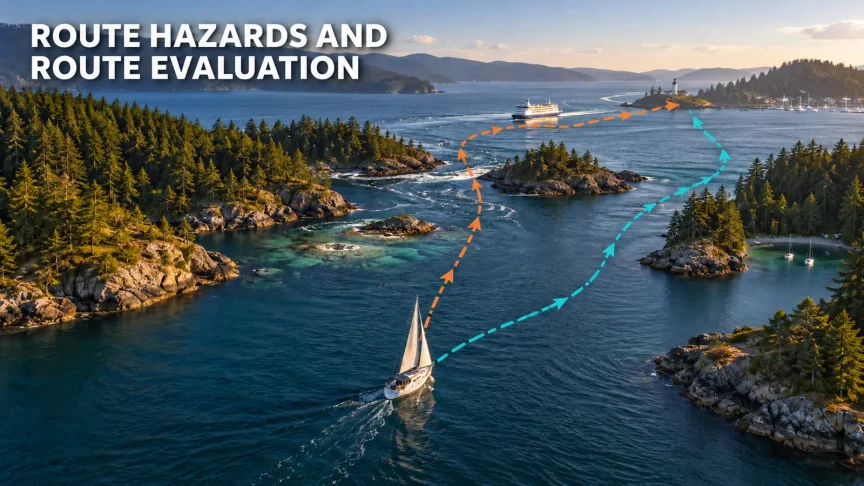
You have checked the chart. You know what the buoys mean. You have looked up the tide and current. You have read the forecast. Now comes the harder question:
Where can you safely take this particular boat, with this particular crew, at this particular time, in these particular conditions?
That is a different question from, “Can the boat physically get through there?” A route may be possible on paper and still be a poor choice. It may pass too close to shallow water, leave little room to avoid traffic, place a tired crew in exposed water or carry the boat beyond the last useful alternate just as conditions begin to worsen.
Route evaluation turns separate pieces of navigation information into judgement. The goal is not to eliminate every hazard. That is rarely possible. The goal is to recognize what matters, understand how the hazards interact, preserve useful margin and keep good options available.
By the end of this lesson, you should be able to scan a proposed route systematically, compare alternatives, choose and defend a prudent route, set decision points and continue evaluating the plan after departure.
Safety note: This lesson teaches a thinking process. It cannot determine whether a real route is safe. Use current official charts, publications, warnings, forecasts and local regulations for the waters you are sailing. Account for your actual vessel, crew and conditions, and seek qualified local instruction or advice when appropriate.
Quick Summary
A hazard is something that can cause harm: a rock, shoal, strong current, traffic route, lee shore or difficult entrance. Risk is the danger that hazard creates for this boat and crew now. Risk changes with time, tide, current, weather, visibility, traffic, boat capability, crew condition and available sea room.
Use this six-step process:
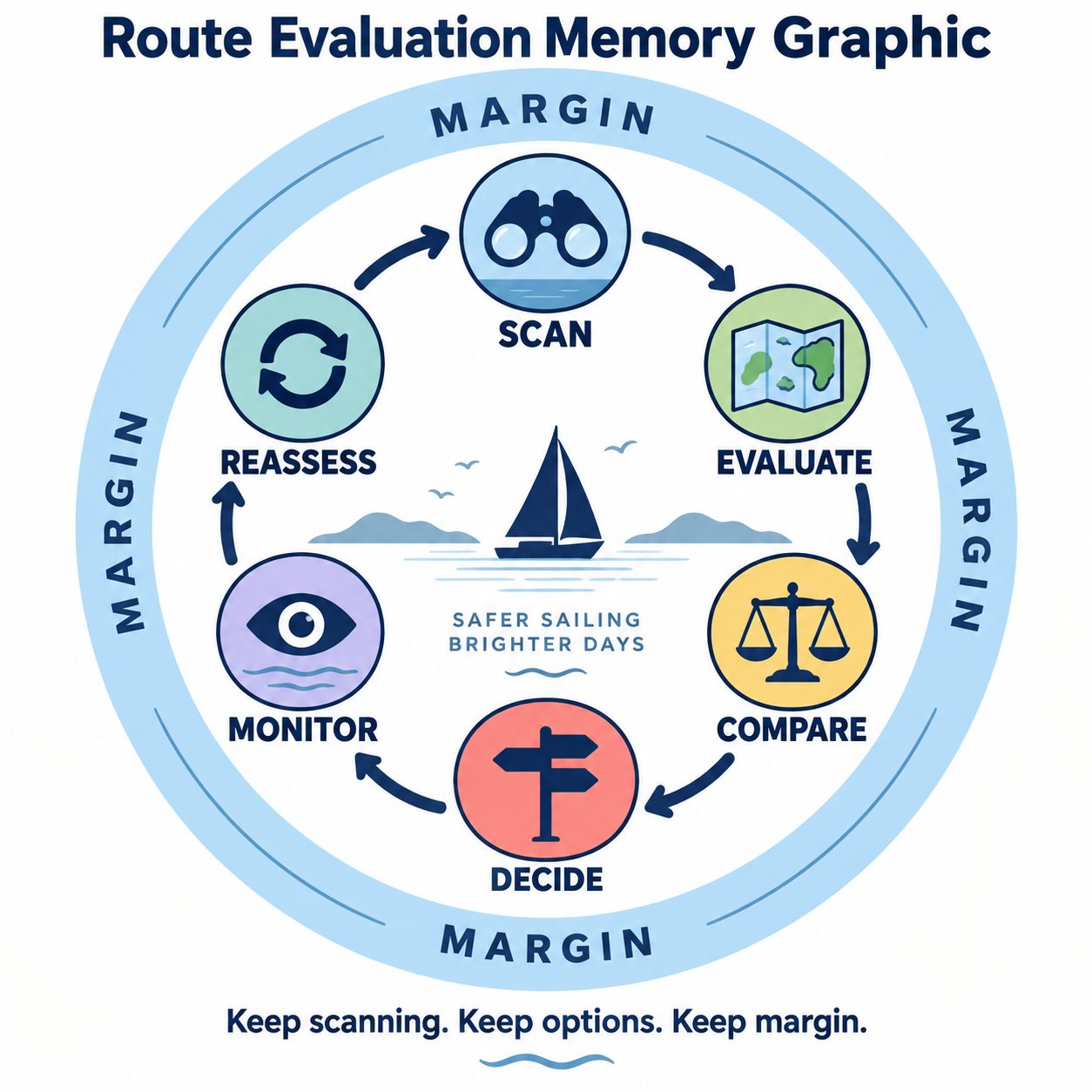
SCAN → EVALUATE → COMPARE → DECIDE → MONITOR → REASSESS
During every step, look through seven lenses:
- Route: What hazards and restrictions exist?
- Water: What will depth, tide and current do?
- Weather: How will wind, waves, visibility and exposure affect the route?
- Boat: What are the boat’s draft, manoeuvring limits and practical capabilities?
- Crew: Can this crew manage the route if it becomes harder?
- Options: Where can you return, divert or find suitable shelter?
- Margin: How much room remains before the situation becomes unacceptable?
Margin is the thread joining the whole process. It is the room that allows an imperfectly steered course, a stronger-than-predicted current, an early wind increase, an avoidance manoeuvre or a seasick crew member to remain a manageable event instead of becoming an emergency.
Table of Contents
- From Seeing Hazards to Evaluating Risk
- Risk Is Dynamic
- Margin: The Room That Keeps Problems Manageable
- A Route Is a Corridor, Not a Thin Line
- The Six-Layer Route-Hazard Scan
- When Hazards Combine, Margin Shrinks
- The Shortest Route Is Not Always the Safest
- Alternatives, Escape Routes and Suitable Shelter
- Decision Points: Decide While Good Options Still Exist
- Monitor and Reassess Underway
- Use Current, Official Information
- Technology Helps, but It Does Not Make the Judgement
- Skipper Thinking Exercises
- Common Route-Evaluation Mistakes
- Knowledge Check, Key Takeaways and Quiz
From Seeing Hazards to Evaluating Risk
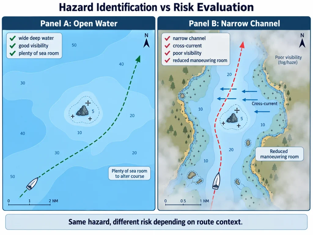
A chart may show a rock very clearly. Spotting it is hazard identification. Deciding whether it makes a proposed route prudent is risk evaluation.
Imagine a rock beside a wide area of deep water. In daylight, good visibility and calm weather, a route that stays well clear may leave generous room to navigate and avoid traffic. The rock remains a hazard, but the route may keep the associated risk low.
Now place the same rock beside a narrow channel. Add a strong cross-current, poor visibility and an inexperienced crew. The rock has not moved, but the practical risk has changed dramatically because the route offers less room for error and fewer ways to recover.
This distinction matters because beginners often react to the most dramatic symbol on the chart while overlooking less obvious factors. A marked rock may attract attention, yet a narrow entrance at dusk with an exhausted crew could be the greater concern.
If soundings, depth contours, rocks, wrecks or chart symbols are still unfamiliar, review How to Read a Nautical Chart before evaluating the route itself. This lesson assumes you can recognize the information; its new task is deciding what that information means for the plan.
Risk Is Dynamic
Hazards are not equally important all the time. The route must be evaluated for the conditions expected when the boat will actually reach each part of it—not only for conditions at departure.
Time, Tide and Current Change the Problem
A shoal passed near high water may have more water over it than it will near low water. That does not automatically make the passage acceptable: actual clearance still depends on current chart information, the applicable water-level prediction or observation, the boat’s draft and an appropriate allowance for uncertainty and conditions.
A charted depth alone does not tell you how much water will be beneath the keel at a particular time. Combine it with the method taught in How to Read Tide Tables, remembering that predicted water levels may differ from observed levels because of weather and other local effects.
Depth and water movement are separate problems. A rising tide does not necessarily mean a favourable current, and slack water does not necessarily occur at high or low water. Use How to Understand Tidal Currents to evaluate how current may alter speed over ground, track, steering workload, arrival time and sea state.
Weather, Visibility and Daylight Change the Workload
An exposed crossing in eight knots of wind may be comfortable. The same crossing in a strengthening 20-knot wind could produce larger waves, more heel, greater leeway and much more demanding sail handling. If wind opposes a strong current, the sea may become shorter and steeper than wind strength alone suggests.
A ferry route crossed in excellent visibility allows earlier detection and more time to understand developing traffic. Fog or heavy rain can remove that advantage. The collision-avoidance responsibilities reviewed in Sailing Right-of-Way Rules still apply, but prudent route evaluation asks an earlier question: can the crossing be made at a better location or time, or avoided if visibility deteriorates?
Daylight is also a resource. An unfamiliar harbour entrance that seems manageable at noon may become much more demanding after a delayed arrival in fading light.
Boat and Crew Change What Is Prudent
Two boats may not have the same practical route. Draft affects where they can go. Manoeuvrability, speed, sail plan and the ability to make progress against wind or current affect how long the boat remains exposed. Engine reliability may matter when the route includes a narrow entrance or limited room to sail.
Crew capability matters just as much. A technically passable entrance may be unsuitable if the crew cannot prepare lines and fenders confidently in waves, if the helmsperson is fatigued or if a crew member is anxious or seasick. The right question is not, “Could this boat survive it?” It is, “Can this boat and crew manage it competently if conditions become harder?”
The later lesson Assess, Brief & Manage a Crew will build directly on this question. When that lesson is published, this paragraph is the natural place to link it: a route suitable for an experienced crew may be inappropriate for two first-time sailors.
Margin: The Room That Keeps Problems Manageable
Margin is the space between normal operation and an unacceptable situation. It is not one fixed number and it cannot be reduced honestly to a red, yellow or green score.
Route margin can take several forms:
- Depth margin: room between the keel and the bottom, considering charted depth, water level, draft, waves and uncertainty.
- Lateral margin: room between the boat’s practical route corridor and rocks, shoals, shorelines or other restrictions.
- Time margin: enough daylight, favourable tide or current, and time before forecast conditions deteriorate.
- Performance margin: enough boat speed, steering control and manoeuvrability to cope with current, waves or traffic.
- Crew margin: enough skill, attention, warmth, energy and confidence for the work required.
- Option margin: useful places and times to return, divert, wait or seek shelter.
Margin is deliberately conservative because plans and predictions are imperfect. A route that works only if the helmsman holds an exact line, the current matches the table precisely and the wind arrives late is not a robust route. It has made success depend on several assumptions all being correct.
Do not solve this by inventing one universal clearance from every rock or one minimum under-keel clearance for every sailboat. Appropriate margin depends on the vessel, waterway, chart quality, conditions, governing requirements and the consequences of being wrong.
A Route Is a Corridor, Not a Thin Line
A line between two waypoints is only a planning reference. The boat occupies space, wanders under normal steering, experiences leeway and is carried by current. It may also need to alter course for traffic, reef a sail, deal with a fouled line or respond to an equipment problem.
Think of the route as a safe-water corridor around the intended track. A useful corridor leaves room for:
- normal steering variation;
- current set and leeway;
- early, obvious collision-avoidance action;
- sail changes or reefing where appropriate;
- uncertainty in position and charted information; and
- recovery from a minor mistake or unexpected problem.
Avoid placing a waypoint directly beside a hazard merely because the electronic route line does not touch the symbol. A waypoint can pull attention and steering toward the very object you want to avoid. Likewise, a route that technically fits between two dangers may offer too little practical room to manoeuvre.
Once hazards have been identified, the plotting and position-awareness skills from Basic Coastal Navigation help turn the safe-water corridor into a route that can be monitored underway.
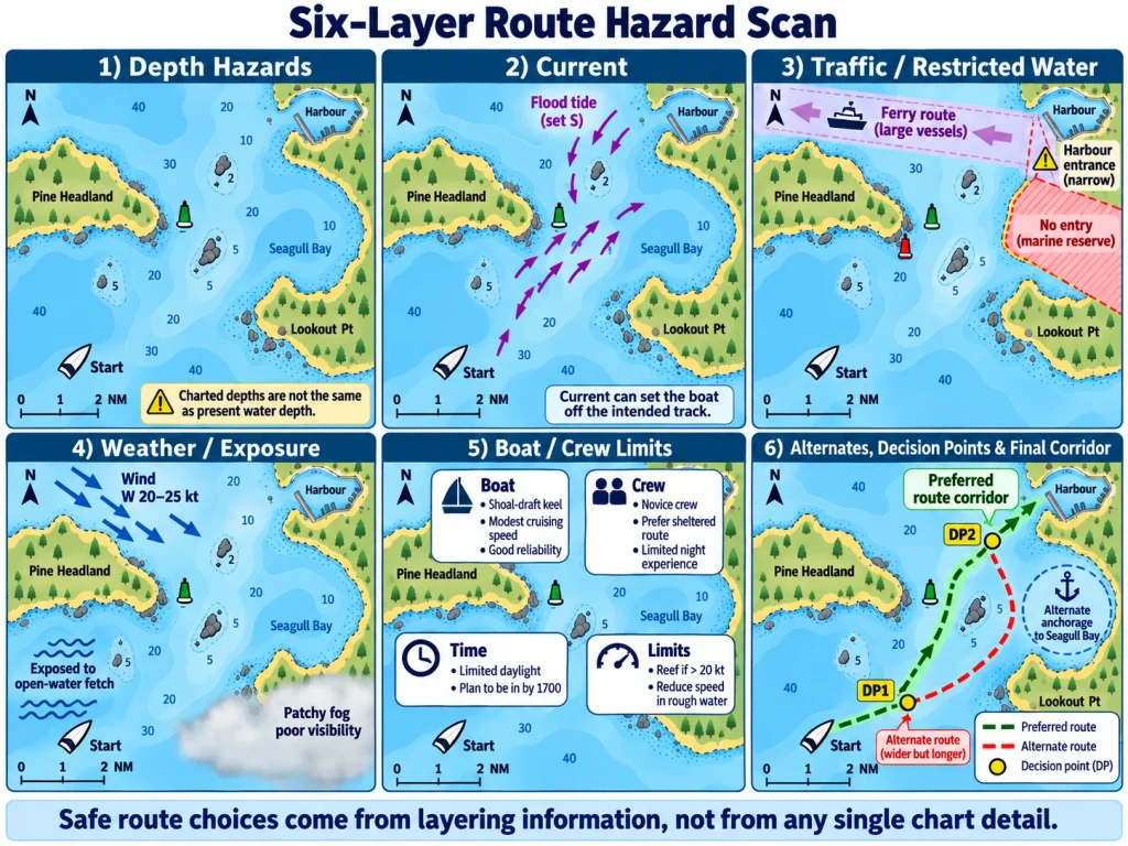
The Six-Layer Route-Hazard Scan
A repeatable scan prevents one obvious hazard from hiding five quieter ones. Work through the proposed route in layers, from departure to destination, and then repeat the scan in the opposite direction. The reverse scan often reveals difficult approaches or lost alternatives that were easy to miss the first time.
Layer 1: Depth and Grounding Hazards
Trace the route corridor and identify shallow water, rocks, reefs, shoals, drying areas, wrecks and obstructions. Note difficult harbour approaches and any places where useful water narrows.
Relate charted information to the boat’s actual draft and to the water level expected at the time of transit. Where bridges or cables are relevant, overhead clearance requires the same disciplined attention to vessel height, vertical datum, water level and official information. Do not assume a route is clear simply because another boat appears to have used it.
Layer 2: Water Movement
Mark strong tidal streams, current acceleration in narrows, current crossing the route, eddies or other locally documented effects. Consider what the current will be doing when you arrive, not merely when you leave.
Ask how current changes the route corridor. Will it set the boat toward a shoal or lee shore? Reduce speed so much that arrival becomes late? Combine with opposing wind to create rougher water? A current that helps on one leg may become a cross-current at the entrance.
Layer 3: Traffic and Restricted Water
Identify ferry routes, shipping channels, harbour entrances, fishing activity and places where traffic concentrates. Look for narrow water where sailboats have fewer course choices or where large vessels may be constrained by draft or channel geometry.
Buoys and marks can help identify channels and dangers, but Aids to Navigation for Beginners explains why they support navigation rather than replace position awareness, a proper lookout or current chart information. An aid may be missing, moved, altered or difficult to identify.
Layer 4: Weather and Exposure
Find exposed shorelines, open-water sections, lee shores and entrances likely to become difficult with a particular wind or sea. Consider the forecast wind direction and trend, wave conditions, visibility, precipitation and daylight at the relevant time.
A lee shore deserves special attention because wind and waves may push the boat toward danger while reducing the space available to solve a problem. Plenty of sea room may keep the risk manageable; little sea room can make the same wind direction far more serious.
Layer 5: Boat and Crew
Now challenge the route with the real boat and crew. Consider draft, manoeuvrability, likely sailing and motoring speed, fuel or battery state where relevant, engine reliability, communications and the complexity of required manoeuvres.
Then consider crew skill, fatigue, cold, anxiety, seasickness and the ability to carry out tasks safely. A longer route is not automatically prudent if it adds hours of exposure and exhausts the crew. A shorter route is not automatically prudent if its saved time is purchased with tight clearances and demanding manoeuvres.
Layer 6: Alternatives and Margin
Finally, mark suitable alternate routes, turnaround points, refuge harbours and places where conditions can be reassessed. Identify where options begin to shrink. Ask whether each alternate is truly usable for this boat in the expected wind, tide, current, visibility and daylight.
Finish by looking at the whole picture. Where is the margin smallest? Which assumptions matter most? Which change would make the route no longer prudent?
When Hazards Combine, Margin Shrinks
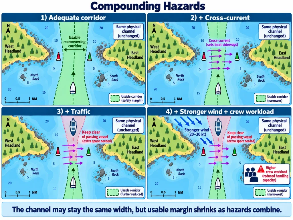
One moderate problem may be manageable. Several moderate problems at the same place and time may not be.
Consider these combinations:
- Strong current + narrow channel: less time to decide and less room to correct the track.
- Falling tide + shallow water: decreasing depth while the boat is still committed to the route.
- Wind opposing current + exposed water: steeper seas, slower progress and greater crew workload.
- Traffic + restricted manoeuvring room: fewer safe course changes when avoidance action is needed.
- Stronger wind + inexperienced crew: harder sail handling at the moment accurate steering matters most.
- Late arrival + unfamiliar harbour + fading daylight: less visual information, more fatigue and fewer easy alternatives.
- Equipment problem + limited sea room: a routine fault becomes urgent because there is no space to troubleshoot.
The key question is not, “Can I handle each item?” Ask, “What happens when they occur together?”
For example, a narrow channel may be comfortable in calm water. A one-knot cross-current may also be manageable in open water. Put that current across the narrow channel, add ferry traffic and give the helm to a tired beginner, and the combined situation may use up most of the available margin.
The Shortest Route Is Not Always the Safest
The straight line looks efficient because its advantage is easy to measure: distance. Its disadvantages may be harder to see until the route is examined in context.
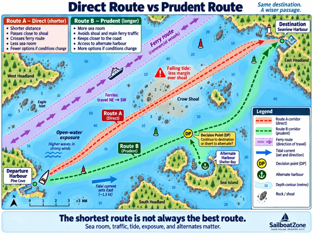
Route A: The Direct Route
Suppose Route A saves about 35 minutes. However, it passes close to a shoal on a falling tide, crosses a busy ferry route, spends more time in exposed water and offers few useful diversion choices.
Route B: The Prudent Route
Route B is longer. It stays farther from the shoal, preserves more sea room, crosses the ferry route where the geometry and visibility are better, and passes an alternate harbour before the exposed section.
Route B is not automatically safer because it is longer. Extra time can create its own risks: later arrival, fatigue, exposure to a forecast wind increase or an unfavourable current. The correct comparison is therefore not short versus long. It is:
What does each route gain, what does it give up, and which one preserves the most useful margin for the conditions expected?
A prudent route often looks less impressive. It may involve waiting, changing the departure time, crossing traffic at a better location, staying in protected water longer or accepting extra distance. What makes it prudent is not caution for its own sake. It is that the choice remains workable when reality is a little worse than predicted.
Alternatives, Escape Routes and Suitable Shelter
An intended destination is where you plan to finish. An alternate destination is another place you have evaluated and could use instead. A refuge or shelter may provide temporary protection without being a practical final destination. A turnaround returns you toward known water. A diversion changes the plan to avoid a developing problem. An escape route is a practical way to move away from danger—but not every coastline offers one.
Do not circle a harbour on the chart and assume the alternate problem is solved. Evaluate its approach, depth, overhead limits where relevant, wind exposure, tide and current, facilities if needed, daylight and crew ability. A harbour on a lee shore with an unfamiliar narrow entrance may be a poor refuge in the very conditions that caused the diversion.
The same route-evaluation thinking becomes more specific at the destination, where depth, protection, swing room and seabed become part of How to Anchor a Sailboat. Harbour entrances and final approaches deserve their own risk picture, leading directly into the close-quarters decisions taught in How to Dock a Sailboat.
Decision Points: Decide While Good Options Still Exist
A decision point is a place or time chosen before departure at which you will compare actual conditions with the plan. It belongs before the difficult section, not in the middle of it.
Useful decision points may be:
- before entering a narrow channel;
- before leaving protected water;
- before crossing a traffic route;
- before passing a suitable alternate harbour;
- before committing to an exposed coastline; or
- before tide or current becomes unfavourable.
At each point, define what you need to observe and what would make you continue, modify, wait, divert or turn back. These are trigger conditions, not predictions. Examples include visibility falling below what the route demands, wind arriving earlier than forecast, speed over ground being too low for daylight, a crew member becoming unwell or an engine warning appearing before a restricted entrance.
Avoid treating one location as a universal “point of no return.” Options usually shrink gradually. Return becomes harder. The alternate gets farther away. Exposure increases. Tide or daylight runs out. Good skipper thinking notices that trend and acts before the remaining choice is forced.
Monitor and Reassess Underway
Departure does not turn the plan into fact. Continue comparing what is happening with what you expected:
- Is the boat where it should be within the route corridor?
- Is speed over ground supporting the planned timing?
- Are depth and water movement broadly consistent with the information used?
- Is the wind building, shifting or producing a different sea state?
- Is visibility changing?
- Is traffic developing as expected?
- Is the crew still able to manage the next section well?
- Are the planned alternate and decision points still suitable and reachable?
A route that looked acceptable at the chart table still has to be monitored on the water. The continuous scan taught in How to Keep a Proper Lookout While Sailing supplies the observations; route evaluation gives those observations meaning.
Reassessment does not require waiting for a dramatic change. Several small differences—slightly stronger current, slightly slower progress, a little less visibility and a crew member becoming tired—may be enough to alter the balance. Act while the alternate remains nearby and the difficult section remains ahead.
Use Current, Official Information
Route judgement is only as good as its inputs. Because depths, obstructions, aids and shoreline information can change or be corrected, begin with an appropriate, current nautical chart; Canadian sailors can obtain official chart information through the Canadian Hydrographic Service.
A chart cannot show every useful detail. Local approaches, preferred routes, tidal streams, weather effects and dangers may require more context, which is why Canadian Sailing Directions are designed to accompany nautical charts.
Before departure, check for temporary or newly reported dangers because the Canadian Coast Guard’s Navigational Warnings can identify changes to aids, marine activity and other hazards affecting navigation.
Outside Canada, use the current official charts, publications, warnings, forecasts and regulations issued or recognized for the waters in which you are sailing. Official systems and requirements vary by jurisdiction, and useful local knowledge should supplement—not replace—official information and careful observation.
Technology Helps, but It Does Not Make the Judgement
Electronic charts, GPS, chartplotters, route-generation tools and depth sounders are enormously useful. They help display position, compare routes, monitor cross-track error, observe depth and update progress.
They also make a poor route look precise.
An automatically generated route may depend on settings or vessel data that are missing, wrong or too optimistic. A route line may pass close to a hazard because the screen scale hides the surrounding detail. Electronic-chart coverage, update status and display choices can affect what the user sees. A depth sounder reports depth at its transducer according to its installation and settings; it does not describe all the water ahead.
Use technology to support the process, then challenge its output:
- Is the underlying chart appropriate and current?
- Have the route corridor and nearby hazards been examined at suitable scales?
- Are tide, current, weather, traffic, boat and crew included in the decision?
- Does the route preserve alternatives and manoeuvring room?
- Can the plan be monitored independently through position, surroundings and depth where useful?
Never follow the magenta line more faithfully than the water around you.
Skipper Thinking: Which Route Would You Choose?
You are skipper of a 9-metre cruising sailboat drawing 1.7 metres. The boat sails comfortably at about 5 knots in moderate conditions, but you are planning on 4.5 knots to allow for manoeuvres and variable wind. The auxiliary engine has operated normally.
You are leaving Cedar Harbour for East Haven. Visibility is about six nautical miles, with haze near the outer coast. Sunset is in five hours. The tide is falling throughout the trip. A cross-current is predicted to strengthen near Gull Shoal and the ferry lane.
The wind is west at 8–12 knots, forecast to build to 18–20 knots late in the afternoon. The timing of the increase is uncertain. Your crew consists of one beginner who has sailed several times and one first-time sailor. Both are rested at departure.
Route A — Direct: approximately 9.5 nautical miles. It saves about 35 minutes, passes near Gull Shoal as the tide falls, crosses the ferry route at an oblique angle and includes a more exposed section of coast. Once committed to that section, useful diversion options are limited.
Route B — Prudent: approximately 12 nautical miles. It remains in deeper, more open water around Gull Shoal, crosses the ferry route at a clearer location, maintains more sea room and passes Pine Bay before the exposed final leg. Pine Bay may be a suitable alternate, but its approach must still be checked for the expected conditions.
Uncertainties remain: the wind may build earlier than forecast, and the coastal haze may reduce visibility near the ferry lane.
Observe
List the facts that affect the decision. Separate observations and official predictions from assumptions. Which information is time-sensitive?
Identify
Mark the hazards on both route corridors: shoal water, falling tide, strengthening cross-current, ferry traffic, exposure, visibility, daylight, crew experience and limited diversion choices.
Evaluate
Which hazards create the greatest risk for this boat and crew today? Where is each route’s smallest margin? Which assumptions would have the largest consequences if wrong?
Compare
What does Route A gain besides time? What margin does it give up? What does Route B gain? What new risk does its extra time create if the wind builds early?
Decide and Defend
Choose Route A, Route B, a delayed departure or another reasonable modification. State the three strongest reasons for your decision. A strong answer must use the scenario evidence; “Route B is longer, so it is safer” is not enough.
Set Triggers
Before departure, identify specific changes that would make you reconsider. Examples might involve visibility, actual speed over ground, wind timing, crew condition or the suitability of Pine Bay. State where you will make each decision while good options remain.
Reassess
Forty-five minutes after departure, the wind rises to 17 knots—earlier than forecast—and the first-time sailor becomes seasick. You have not yet passed Pine Bay.
What changed? Which margins became smaller? Does your original route still make sense? What should you do before Pine Bay is behind you?
There is no prize for guessing the author’s route. The goal is a defensible decision that matches the evidence, preserves margin and states what would trigger another change.
Skipper Thinking: Act Before the Options Disappear
You chose a route that enters a narrow channel after crossing two miles of open water. The forecast called for 10 knots, but halfway across, the wind reaches 18 knots against the current. Progress slows, waves become steeper and one crew member is struggling to work safely. You can still return to protected water; the channel entrance is ahead, and a suitable alternate lies abeam.
Ask:
- What changed from the plan?
- Which margins became smaller—time, crew, performance, sea room or options?
- Which options still exist?
- What decision should be made before the boat reaches the channel?
The thinking sequence is:
MONITOR → COMPARE ACTUAL WITH EXPECTED → ACT EARLY → REASSESS
A route that looked prudent at departure is not a promise. It is a decision based on information available at the time.
Common Route-Evaluation Mistakes
Drawing a Straight Line and Calling It a Route
A line shows intention, not the width of safe water needed for steering error, leeway, current, traffic avoidance or an unexpected problem. Evaluate a corridor.
Planning Too Close to Hazards
Do not make success depend on exact steering, exact predictions or perfect position information. Preserve margin appropriate to the situation rather than copying a universal distance.
Looking Only at Charted Depth
Relate charted depth to the applicable datum, expected and observed water level, vessel draft, conditions and uncertainty. Do not confuse tide height with tidal-current strength or timing.
Evaluating Departure but Not Arrival
Forecast wind, tide, current, visibility, daylight and crew condition at each difficult part of the route, especially the destination approach.
Treating Each Hazard Separately
Ask which hazards occur together. Moderate current, traffic and fatigue can consume more margin than one obvious rock kept well clear.
Assuming Aids Guarantee Safe Water
Aids mark or support navigation according to the local system; they do not replace the chart, lookout or position awareness, and they may be altered, missing or difficult to identify.
Blindly Accepting an Automatic Route
Inspect the source chart, settings, vessel data, scales, hazards and route corridor. The tool cannot evaluate an anxious crew or a doubtful alternate harbour for you.
Choosing the Shortest Route by Default
Compare time saved with sea room, exposure, traffic geometry, crew workload and diversion opportunities. Also challenge a longer route if its extra time creates new problems.
Missing the Last Good Decision Point
Reassess before entering restricted water or passing a suitable alternate. A late decision is often a choice among fewer and worse options.
Planning for What the Boat Can Endure
The prudent limit is often set by the people aboard, not the maximum capability of the hull and rig.
Becoming Loyal to the Original Plan
Changing, delaying, diverting or turning back is not failure. Continuing after the reasons for the plan have changed is the more serious error.
Knowledge Check
Answer these without looking back. Use complete reasons rather than one-word answers.
- A rock appears on the chart beside a proposed route. What is the difference between identifying the hazard and evaluating the risk?
- Why might a shoal create a different risk near high water than near low water, and what information is still needed before judging the route?
- A narrow channel and a strong cross-current are each manageable on their own. Why may their combination be more serious?
- What is a route corridor, and why should it include more than the width of the boat?
- Give two reasons the longer of two routes might be more prudent and two reasons it might not be.
- What makes a harbour a genuine alternate rather than simply a harbour shown nearby on the chart?
- Where should a decision point be placed relative to a difficult route section, and why?
- Name three changes underway that should trigger reassessment. For each, identify which margin may be shrinking.
Key Takeaways
- Find the hazards. Scan the complete route systematically.
- Understand what makes them matter. Risk changes with water, weather, boat, crew, time and traffic.
- Look at the whole route. Hazards can combine, and the hardest section may occur near arrival.
- Plan a corridor, not a thread. Leave room to steer, avoid traffic and solve small problems.
- Preserve margin. Do not build a plan that works only if every assumption is correct.
- Compare real trade-offs. Shorter is not automatically safer; longer is not automatically prudent.
- Keep alternatives. Evaluate them rather than merely naming them.
- Decide early. Reassess before useful options shrink.
- Monitor reality. A route decision continues after departure.
Route Hazards and Route Evaluation Quiz
1. Hazard or Risk?
A charted shoal lies half a nautical mile from a proposed route. Which statement shows the best judgement?
A. The shoal is marked, so it is no longer a hazard.
B. The shoal makes the route unsafe in every condition.
C. The shoal is a hazard; its risk depends on the route corridor, depth, tide, conditions, boat, crew and available margin.
D. The chartplotter route avoids the symbol, so no further evaluation is needed.
2. Charted Depth and Tide
A route crosses shallow water late in a falling tide. What should the skipper do first?
A. Add the boat’s speed to the charted depth.
B. Evaluate current chart information, applicable water level, vessel draft, conditions and an appropriate margin.
C. Assume the depth sounder will provide enough warning.
D. Continue because falling tide always means weaker current.
3. Route Corridor
Why should a planned route have a safe-water corridor rather than only a thin line?
A. A wider line makes the chart easier to read.
B. It allows for steering variation, current, leeway, traffic avoidance and unexpected problems.
C. It guarantees the boat will not ground.
D. It removes the need to monitor position.
4. Compounding Hazards
Which combination most clearly illustrates compounding risk?
A. A marked rock well outside the route in clear, calm weather.
B. Deep open water with a rested crew.
C. A narrow channel, strengthening cross-current, concentrated traffic and a tired helmsperson.
D. A longer route with two suitable alternate harbours.
5. Choosing Between Routes
Route A saves 35 minutes but passes close to a shoal on a falling tide and offers few diversions. Route B takes longer, preserves sea room and passes a suitable alternate, but may arrive closer to a forecast wind increase. What is the best approach?
A. Always choose Route B because longer routes are safer.
B. Always choose Route A because less time underway means less risk.
C. Compare the hazards, timing and margins of both routes, and consider changing the departure time or plan if neither remains robust.
D. Let the chartplotter choose automatically.
6. Ferry Crossing
A route crosses a ferry lane in deteriorating visibility. Which choice best preserves margin?
A. Maintain the original route because sailing vessels always have priority.
B. Reassess early, maintain a proper lookout and consider a clearer crossing location, different timing or alternate route before options narrow.
C. Turn off the chartplotter to reduce distraction.
D. Cross as quickly as possible without changing the plan.
7. Crew Capability
An entrance is passable for the boat, but the crew is cold, tired and struggling with lines. What should the skipper conclude?
A. Boat capability is the only relevant factor.
B. The entrance remains prudent because the destination is close.
C. Crew condition has reduced the practical margin, so the approach and available alternatives must be reassessed before commitment.
D. The crew will perform better once the entrance becomes busy.
8. Evaluating an Alternate
Which statement about an alternate harbour is most accurate?
A. Any harbour symbol makes a suitable refuge.
B. An alternate is useful only after the original destination becomes impossible.
C. Its approach, depth, exposure, tide/current, daylight and crew demands must be evaluated before relying on it.
D. Facilities are the only important consideration.
9. Decision Point
Where is the best place for a decision point before an exposed section?
A. After the boat has passed the last suitable alternate.
B. In the most difficult water, when the actual risk is obvious.
C. While the boat can still continue, return or divert using workable options.
D. Only at the dock before departure.
10. Reassessment Underway
The wind builds earlier than forecast, speed over ground falls and sunset is approaching. What should happen?
A. Continue because changing the plan shows poor preparation.
B. Compare actual conditions with the plan, identify shrinking margins and act before the remaining alternatives become harder to use.
C. Increase speed regardless of conditions.
D. Wait until the route becomes clearly impossible.
Answer Key
- C. The shoal is the hazard. Risk depends on how the real route, conditions, boat and crew interact with it. This answer avoids both complacency and the false claim that every nearby shoal makes every route unsafe.
- B. Present and future clearance cannot be judged from one sounding alone. The decision needs current chart information, relevant water-level information, actual draft, conditions and appropriate margin. Tide height and current are not interchangeable.
- B. The boat does not travel perfectly along a dimensionless line. A corridor preserves space for ordinary variation and necessary action. It improves margin but cannot guarantee safety.
- C. Each factor uses some of the same limited manoeuvring and attention margin. Together they may create a serious situation even if each seems manageable alone.
- C. Both routes have costs. Good judgement compares the complete situation and is willing to modify timing or reject both options when the plan depends on optimistic assumptions.
- B. Collision responsibilities still apply, but the route should be reassessed before the crossing becomes urgent. Better geometry, timing or an alternate can preserve visibility, time and manoeuvring margin.
- C. A route is evaluated for the actual crew as well as the hull. Acting before commitment preserves the ability to wait, divert or choose an easier approach.
- C. A nearby harbour is not automatically suitable. Its route and approach must be evaluated for the same changing factors as the main destination.
- C. Decision points work best while several workable choices remain. Waiting until the difficult section turns a planned decision into a pressured reaction.
- B. Route evaluation continues underway. Early action protects time and option margin; loyalty to an outdated plan does not.
Scoring Guide
9–10: Strong Understanding
You are beginning to evaluate routes rather than merely follow them. Continue practising with different boats, crews and changing conditions.
7–8: Developing Skipper Judgement
Review the questions you missed and repeat the related sections. Pay particular attention to how margin and alternatives change the route choice.
5–6: Important Gaps
Revisit hazard versus risk, route corridors, compounding hazards, alternatives and decision points before moving forward.
0–4: Review the Prerequisites
Return to chart reading, tides, tidal currents, aids to navigation and basic coastal navigation. Then repeat this lesson and quiz. This score supports learning; it is not a certification of navigational competence.
What Comes Next?
You began this part of the course by learning to recognize what is around you: vessels, marks, charted features, water depth, tide and current. In this lesson, those separate facts became a route decision.
Next, you will apply the same thinking more closely to anchoring, mooring and docking approaches. Later, How to Plan a Sailing Trip will combine route, weather, crew, timing, communications and contingencies into a complete plan. The Independent Skipper Capstone will eventually ask you to use this process without being told which hazard deserves the most attention.
The planned Skipper Decision-Making lesson is another natural forward link from this point. Route evaluation identifies the facts, uncertainties and available margins; skipper decision-making turns them into a defensible choice to go, modify, delay or stay.
You are no longer learning only how navigation works.
You are beginning to learn how a skipper uses navigation information to make decisions.